You are here: Home > Network List > TA - USArray Transportable Network (new EarthScope stations) Stations List
> Station J17A Brown Place, Jackson, WY, USA > Earthquake Result Viewer
J17A Brown Place, Jackson, WY, USA - Earthquake Result Viewer

| Earthquake location: |
North Of Honduras |
| Earthquake latitude/longitude: |
17.2/-84.8 |
| Earthquake time(UTC): |
2008/03/27 (087) 09:42:57 GMT |
| Earthquake Depth: |
10 km |
| Earthquake Magnitude: |
5.6 MW, 5.1 MS, 5.4 MB, 5.6 MW |
| Earthquake Catalog/Contributor: |
WHDF/NEIC |
|
| Network: |
TA USArray Transportable Network (new EarthScope stations) |
| Station: |
J17A Brown Place, Jackson, WY, USA |
| Lat/Lon: |
43.36 N/110.71 W |
| Elevation: |
1975 m |
|
| Distance: |
34.1 deg |
| Az: |
325.383 deg |
| Baz: |
131.882 deg |
| Ray Param: |
0.07791322 |
| Estimated Moho Depth: |
17.75 km |
| Estimated Crust Vp/Vs: |
2.09 |
| Assumed Crust Vp: |
6.207 km/s |
| Estimated Crust Vs: |
2.966 km/s |
| Estimated Crust Poisson's Ratio: |
0.35 |
|
| Radial Match: |
81.54646 % |
| Radial Bump: |
400 |
| Transverse Match: |
83.69216 % |
| Transverse Bump: |
400 |
| SOD ConfigId: |
2564 |
| Insert Time: |
2010-03-06 15:08:22.716 +0000 |
| GWidth: |
2.5 |
| Max Bumps: |
400 |
| Tol: |
0.001 |
|
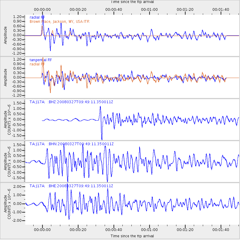
Signal To Noise
| Channel | StoN | STA | LTA |
| TA:J17A: :BHN:20080327T09:49:11.350011Z | 4.4653487 | 6.040556E-7 | 1.3527624E-7 |
| TA:J17A: :BHE:20080327T09:49:11.350011Z | 5.129315 | 5.811275E-7 | 1.1329534E-7 |
| TA:J17A: :BHZ:20080327T09:49:11.350011Z | 11.071858 | 6.5678813E-7 | 5.9320495E-8 |
| Arrivals |
| Ps | 3.3 SECOND |
| PpPs | 8.3 SECOND |
| PsPs/PpSs | 12 SECOND |


