You are here: Home > Network List > TA - USArray Transportable Network (new EarthScope stations) Stations List
> Station J17A Brown Place, Jackson, WY, USA > Earthquake Result Viewer
J17A Brown Place, Jackson, WY, USA - Earthquake Result Viewer
| Earthquake location: |
Santa Cruz Islands Region |
| Earthquake latitude/longitude: |
-11.0/164.5 |
| Earthquake time(UTC): |
2008/07/19 (201) 09:27:01 GMT |
| Earthquake Depth: |
11 km |
| Earthquake Magnitude: |
6.1 MB, 6.4 MS, 6.6 MW, 6.6 MW |
| Earthquake Catalog/Contributor: |
WHDF/NEIC |
|
| Network: |
TA USArray Transportable Network (new EarthScope stations) |
| Station: |
J17A Brown Place, Jackson, WY, USA |
| Lat/Lon: |
43.36 N/110.71 W |
| Elevation: |
1975 m |
|
| Distance: |
93.7 deg |
| Az: |
46.707 deg |
| Baz: |
258.455 deg |
| Ray Param: |
0.04120055 |
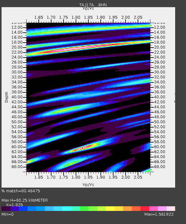
| Estimated Moho Depth: |
60.25 km |
| Estimated Crust Vp/Vs: |
1.83 |
| Assumed Crust Vp: |
6.207 km/s |
| Estimated Crust Vs: |
3.401 km/s |
| Estimated Crust Poisson's Ratio: |
0.29 |
|
| Radial Match: |
80.46475 % |
| Radial Bump: |
400 |
| Transverse Match: |
71.64059 % |
| Transverse Bump: |
400 |
| SOD ConfigId: |
2658 |
| Insert Time: |
2010-03-06 15:08:26.473 +0000 |
| GWidth: |
2.5 |
| Max Bumps: |
400 |
| Tol: |
0.001 |
|

Signal To Noise
| Channel | StoN | STA | LTA |
| TA:J17A: :BHN:20080719T09:39:46.550027Z | 15.919601 | 6.0667816E-7 | 3.810888E-8 |
| TA:J17A: :BHE:20080719T09:39:46.550027Z | 4.0309134 | 1.8822197E-7 | 4.669462E-8 |
| TA:J17A: :BHZ:20080719T09:39:46.550027Z | 3.1389284 | 3.2799426E-7 | 1.0449243E-7 |
| Arrivals |
| Ps | 8.2 SECOND |
| PpPs | 27 SECOND |
| PsPs/PpSs | 35 SECOND |


