You are here: Home > Network List > AV - Alaska Volcano Observatory Stations List
> Station SPCR Ckakachatna River, Mount Spurr, Alaska > Earthquake Result Viewer
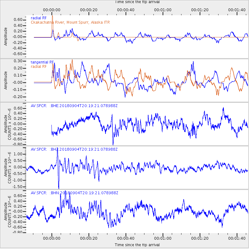
SPCR Ckakachatna River, Mount Spurr, Alaska - Earthquake Result Viewer
*The percent match for this event was below the threshold and hence no stack was calculated.
| Earthquake location: |
Near East Coast Of Honshu, Japan |
| Earthquake latitude/longitude: |
36.4/141.5 |
| Earthquake time(UTC): |
2018/09/04 (247) 20:11:19 GMT |
| Earthquake Depth: |
39 km |
| Earthquake Magnitude: |
5.4 Mww |
| Earthquake Catalog/Contributor: |
NEIC PDE/us |
|
| Network: |
AV Alaska Volcano Observatory |
| Station: |
SPCR Ckakachatna River, Mount Spurr, Alaska |
| Lat/Lon: |
61.20 N/152.21 W |
| Elevation: |
984 m |
|
| Distance: |
47.6 deg |
| Az: |
36.909 deg |
| Baz: |
270.18 deg |
| Ray Param: |
$rayparam |
*The percent match for this event was below the threshold and hence was not used in the summary stack. |
|
| Radial Match: |
60.21689 % |
| Radial Bump: |
400 |
| Transverse Match: |
51.942745 % |
| Transverse Bump: |
400 |
| SOD ConfigId: |
13570011 |
| Insert Time: |
2019-05-01 02:13:38.762 +0000 |
| GWidth: |
2.5 |
| Max Bumps: |
400 |
| Tol: |
0.001 |
|
Signal To Noise
| Channel | StoN | STA | LTA |
| AV:SPCR: :BHZ:20180904T20:19:21.078988Z | 2.9288568 | 6.0541356E-7 | 2.0670643E-7 |
| AV:SPCR: :BHN:20180904T20:19:21.078988Z | 1.1220131 | 2.0024439E-7 | 1.7846885E-7 |
| AV:SPCR: :BHE:20180904T20:19:21.078988Z | 1.348493 | 3.0582152E-7 | 2.2678762E-7 |
| Arrivals |
| Ps | |
| PpPs | |
| PsPs/PpSs | |


