You are here: Home > Network List > TA - USArray Transportable Network (new EarthScope stations) Stations List
> Station J17A Brown Place, Jackson, WY, USA > Earthquake Result Viewer
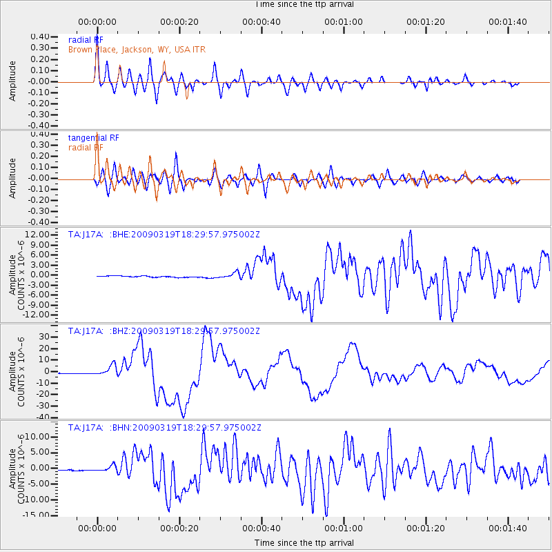
J17A Brown Place, Jackson, WY, USA - Earthquake Result Viewer

| Earthquake location: |
Tonga Islands Region |
| Earthquake latitude/longitude: |
-23.0/-174.7 |
| Earthquake time(UTC): |
2009/03/19 (078) 18:17:40 GMT |
| Earthquake Depth: |
34 km |
| Earthquake Magnitude: |
7.0 MB, 7.6 MS, 7.6 MW, 7.6 MW |
| Earthquake Catalog/Contributor: |
WHDF/NEIC |
|
| Network: |
TA USArray Transportable Network (new EarthScope stations) |
| Station: |
J17A Brown Place, Jackson, WY, USA |
| Lat/Lon: |
43.36 N/110.71 W |
| Elevation: |
1975 m |
|
| Distance: |
88.4 deg |
| Az: |
40.956 deg |
| Baz: |
235.881 deg |
| Ray Param: |
0.042605355 |
| Estimated Moho Depth: |
66.75 km |
| Estimated Crust Vp/Vs: |
1.73 |
| Assumed Crust Vp: |
6.207 km/s |
| Estimated Crust Vs: |
3.598 km/s |
| Estimated Crust Poisson's Ratio: |
0.25 |
|
| Radial Match: |
93.40125 % |
| Radial Bump: |
400 |
| Transverse Match: |
85.425934 % |
| Transverse Bump: |
400 |
| SOD ConfigId: |
2658 |
| Insert Time: |
2010-03-06 15:08:31.257 +0000 |
| GWidth: |
2.5 |
| Max Bumps: |
400 |
| Tol: |
0.001 |
|
Signal To Noise
| Channel | StoN | STA | LTA |
| TA:J17A: :BHZ:20090319T18:29:57.975002Z | 13.640897 | 4.6275027E-6 | 3.3923743E-7 |
| TA:J17A: :BHN:20090319T18:29:57.975002Z | 5.7491183 | 9.571709E-7 | 1.6649003E-7 |
| TA:J17A: :BHE:20090319T18:29:57.975002Z | 4.7413316 | 8.665398E-7 | 1.8276296E-7 |
| Arrivals |
| Ps | 8.0 SECOND |
| PpPs | 29 SECOND |
| PsPs/PpSs | 37 SECOND |


