You are here: Home > Network List > TA - USArray Transportable Network (new EarthScope stations) Stations List
> Station J17A Brown Place, Jackson, WY, USA > Earthquake Result Viewer
J17A Brown Place, Jackson, WY, USA - Earthquake Result Viewer
| Earthquake location: |
Northern Chile |
| Earthquake latitude/longitude: |
-22.2/-69.9 |
| Earthquake time(UTC): |
2007/11/14 (318) 15:40:50 GMT |
| Earthquake Depth: |
40 km |
| Earthquake Magnitude: |
6.7 MB, 7.4 MS, 7.7 MW, 7.4 ME |
| Earthquake Catalog/Contributor: |
WHDF/NEIC |
|
| Network: |
TA USArray Transportable Network (new EarthScope stations) |
| Station: |
J17A Brown Place, Jackson, WY, USA |
| Lat/Lon: |
43.36 N/110.71 W |
| Elevation: |
1975 m |
|
| Distance: |
75.3 deg |
| Az: |
330.469 deg |
| Baz: |
141.235 deg |
| Ray Param: |
0.051696897 |
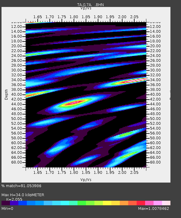
| Estimated Moho Depth: |
34.0 km |
| Estimated Crust Vp/Vs: |
2.06 |
| Assumed Crust Vp: |
6.207 km/s |
| Estimated Crust Vs: |
3.02 km/s |
| Estimated Crust Poisson's Ratio: |
0.34 |
|
| Radial Match: |
91.053986 % |
| Radial Bump: |
400 |
| Transverse Match: |
72.7078 % |
| Transverse Bump: |
400 |
| SOD ConfigId: |
2564 |
| Insert Time: |
2010-03-06 15:08:45.827 +0000 |
| GWidth: |
2.5 |
| Max Bumps: |
400 |
| Tol: |
0.001 |
|
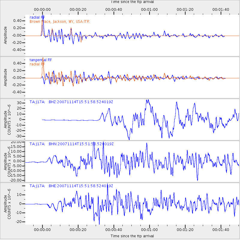
Signal To Noise
| Channel | StoN | STA | LTA |
| TA:J17A: :BHN:20071114T15:51:58.524019Z | 12.260938 | 1.9149243E-6 | 1.5618092E-7 |
| TA:J17A: :BHE:20071114T15:51:58.524019Z | 14.058325 | 1.6447841E-6 | 1.16997164E-7 |
| TA:J17A: :BHZ:20071114T15:51:58.524019Z | 21.002674 | 5.4386937E-6 | 2.5895244E-7 |
| Arrivals |
| Ps | 5.9 SECOND |
| PpPs | 16 SECOND |
| PsPs/PpSs | 22 SECOND |


