You are here: Home > Network List > TA - USArray Transportable Network (new EarthScope stations) Stations List
> Station D25K Kavik River, AK, USA > Earthquake Result Viewer
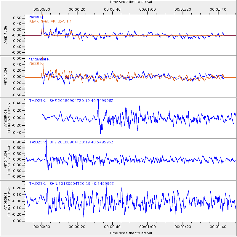
D25K Kavik River, AK, USA - Earthquake Result Viewer
*The percent match for this event was below the threshold and hence no stack was calculated.
| Earthquake location: |
Near East Coast Of Honshu, Japan |
| Earthquake latitude/longitude: |
36.4/141.5 |
| Earthquake time(UTC): |
2018/09/04 (247) 20:11:19 GMT |
| Earthquake Depth: |
39 km |
| Earthquake Magnitude: |
5.4 Mww |
| Earthquake Catalog/Contributor: |
NEIC PDE/us |
|
| Network: |
TA USArray Transportable Network (new EarthScope stations) |
| Station: |
D25K Kavik River, AK, USA |
| Lat/Lon: |
69.32 N/146.38 W |
| Elevation: |
770 m |
|
| Distance: |
50.1 deg |
| Az: |
26.126 deg |
| Baz: |
268.377 deg |
| Ray Param: |
$rayparam |
*The percent match for this event was below the threshold and hence was not used in the summary stack. |
|
| Radial Match: |
66.762405 % |
| Radial Bump: |
400 |
| Transverse Match: |
56.398964 % |
| Transverse Bump: |
400 |
| SOD ConfigId: |
13570011 |
| Insert Time: |
2019-05-01 02:19:35.602 +0000 |
| GWidth: |
2.5 |
| Max Bumps: |
400 |
| Tol: |
0.001 |
|
Signal To Noise
| Channel | StoN | STA | LTA |
| TA:D25K: :BHZ:20180904T20:19:40.549996Z | 4.8358116 | 3.0127265E-7 | 6.230032E-8 |
| TA:D25K: :BHN:20180904T20:19:40.549996Z | 1.3279628 | 9.488254E-8 | 7.14497E-8 |
| TA:D25K: :BHE:20180904T20:19:40.549996Z | 3.2964427 | 1.8820597E-7 | 5.7093658E-8 |
| Arrivals |
| Ps | |
| PpPs | |
| PsPs/PpSs | |


