You are here: Home > Network List > TA - USArray Transportable Network (new EarthScope stations) Stations List
> Station F21K Alatna River, AK, USA > Earthquake Result Viewer
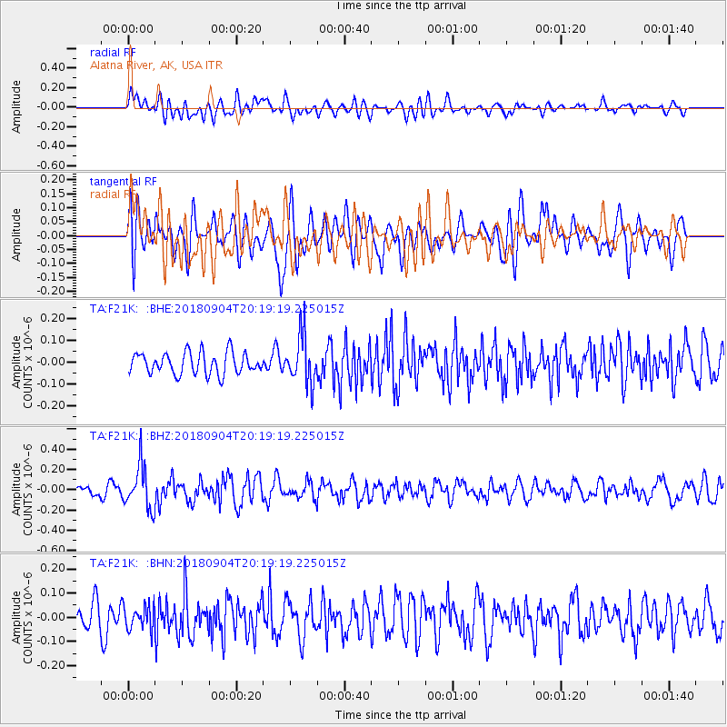
F21K Alatna River, AK, USA - Earthquake Result Viewer
*The percent match for this event was below the threshold and hence no stack was calculated.
| Earthquake location: |
Near East Coast Of Honshu, Japan |
| Earthquake latitude/longitude: |
36.4/141.5 |
| Earthquake time(UTC): |
2018/09/04 (247) 20:11:19 GMT |
| Earthquake Depth: |
39 km |
| Earthquake Magnitude: |
5.4 Mww |
| Earthquake Catalog/Contributor: |
NEIC PDE/us |
|
| Network: |
TA USArray Transportable Network (new EarthScope stations) |
| Station: |
F21K Alatna River, AK, USA |
| Lat/Lon: |
67.22 N/153.48 W |
| Elevation: |
597 m |
|
| Distance: |
47.3 deg |
| Az: |
28.67 deg |
| Baz: |
263.457 deg |
| Ray Param: |
$rayparam |
*The percent match for this event was below the threshold and hence was not used in the summary stack. |
|
| Radial Match: |
50.373764 % |
| Radial Bump: |
400 |
| Transverse Match: |
52.760914 % |
| Transverse Bump: |
400 |
| SOD ConfigId: |
13570011 |
| Insert Time: |
2019-05-01 02:19:50.605 +0000 |
| GWidth: |
2.5 |
| Max Bumps: |
400 |
| Tol: |
0.001 |
|
Signal To Noise
| Channel | StoN | STA | LTA |
| TA:F21K: :BHZ:20180904T20:19:19.225015Z | 4.4565725 | 2.195609E-7 | 4.9266763E-8 |
| TA:F21K: :BHN:20180904T20:19:19.225015Z | 0.76397705 | 4.8472074E-8 | 6.344703E-8 |
| TA:F21K: :BHE:20180904T20:19:19.225015Z | 2.2291844 | 1.1127655E-7 | 4.9918057E-8 |
| Arrivals |
| Ps | |
| PpPs | |
| PsPs/PpSs | |


