You are here: Home > Network List > TA - USArray Transportable Network (new EarthScope stations) Stations List
> Station H23K Yukon River, AK, USA > Earthquake Result Viewer
H23K Yukon River, AK, USA - Earthquake Result Viewer
| Earthquake location: |
Near East Coast Of Honshu, Japan |
| Earthquake latitude/longitude: |
36.4/141.5 |
| Earthquake time(UTC): |
2018/09/04 (247) 20:11:19 GMT |
| Earthquake Depth: |
39 km |
| Earthquake Magnitude: |
5.4 Mww |
| Earthquake Catalog/Contributor: |
NEIC PDE/us |
|
| Network: |
TA USArray Transportable Network (new EarthScope stations) |
| Station: |
H23K Yukon River, AK, USA |
| Lat/Lon: |
65.83 N/149.54 W |
| Elevation: |
617 m |
|
| Distance: |
48.8 deg |
| Az: |
30.7 deg |
| Baz: |
268.424 deg |
| Ray Param: |
0.06901811 |
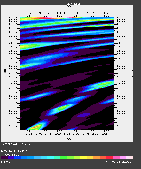
| Estimated Moho Depth: |
10.0 km |
| Estimated Crust Vp/Vs: |
1.81 |
| Assumed Crust Vp: |
6.566 km/s |
| Estimated Crust Vs: |
3.623 km/s |
| Estimated Crust Poisson's Ratio: |
0.28 |
|
| Radial Match: |
83.26204 % |
| Radial Bump: |
400 |
| Transverse Match: |
61.960514 % |
| Transverse Bump: |
400 |
| SOD ConfigId: |
13570011 |
| Insert Time: |
2019-05-01 02:20:13.707 +0000 |
| GWidth: |
2.5 |
| Max Bumps: |
400 |
| Tol: |
0.001 |
|

Signal To Noise
| Channel | StoN | STA | LTA |
| TA:H23K: :BHZ:20180904T20:19:30.625009Z | 7.6851225 | 4.6730537E-7 | 6.080649E-8 |
| TA:H23K: :BHN:20180904T20:19:30.625009Z | 1.5249953 | 9.185335E-8 | 6.023189E-8 |
| TA:H23K: :BHE:20180904T20:19:30.625009Z | 3.9084167 | 1.633891E-7 | 4.1804423E-8 |
| Arrivals |
| Ps | 1.3 SECOND |
| PpPs | 4.0 SECOND |
| PsPs/PpSs | 5.3 SECOND |


