You are here: Home > Network List > TA - USArray Transportable Network (new EarthScope stations) Stations List
> Station L20K Farewell, AK, USA > Earthquake Result Viewer
L20K Farewell, AK, USA - Earthquake Result Viewer
*The percent match for this event was below the threshold and hence no stack was calculated.
| Earthquake location: |
Near East Coast Of Honshu, Japan |
| Earthquake latitude/longitude: |
36.4/141.5 |
| Earthquake time(UTC): |
2018/09/04 (247) 20:11:19 GMT |
| Earthquake Depth: |
39 km |
| Earthquake Magnitude: |
5.4 Mww |
| Earthquake Catalog/Contributor: |
NEIC PDE/us |
|
| Network: |
TA USArray Transportable Network (new EarthScope stations) |
| Station: |
L20K Farewell, AK, USA |
| Lat/Lon: |
62.48 N/153.88 W |
| Elevation: |
673 m |
|
| Distance: |
46.8 deg |
| Az: |
35.139 deg |
| Baz: |
267.506 deg |
| Ray Param: |
$rayparam |
*The percent match for this event was below the threshold and hence was not used in the summary stack. |
|
| Radial Match: |
67.31899 % |
| Radial Bump: |
400 |
| Transverse Match: |
61.211525 % |
| Transverse Bump: |
400 |
| SOD ConfigId: |
13570011 |
| Insert Time: |
2019-05-01 02:20:40.701 +0000 |
| GWidth: |
2.5 |
| Max Bumps: |
400 |
| Tol: |
0.001 |
|
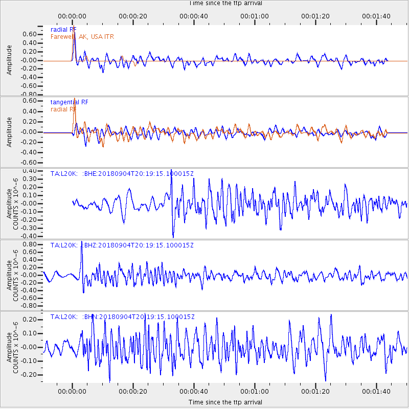
Signal To Noise
| Channel | StoN | STA | LTA |
| TA:L20K: :BHZ:20180904T20:19:15.100015Z | 3.2913008 | 2.5446604E-7 | 7.731473E-8 |
| TA:L20K: :BHN:20180904T20:19:15.100015Z | 1.5826569 | 5.0953382E-8 | 3.219484E-8 |
| TA:L20K: :BHE:20180904T20:19:15.100015Z | 2.3594074 | 1.6913917E-7 | 7.168714E-8 |
| Arrivals |
| Ps | |
| PpPs | |
| PsPs/PpSs | |


