You are here: Home > Network List > US - United States National Seismic Network Stations List
> Station ERPA Erie, Pennsylvania, USA > Earthquake Result Viewer
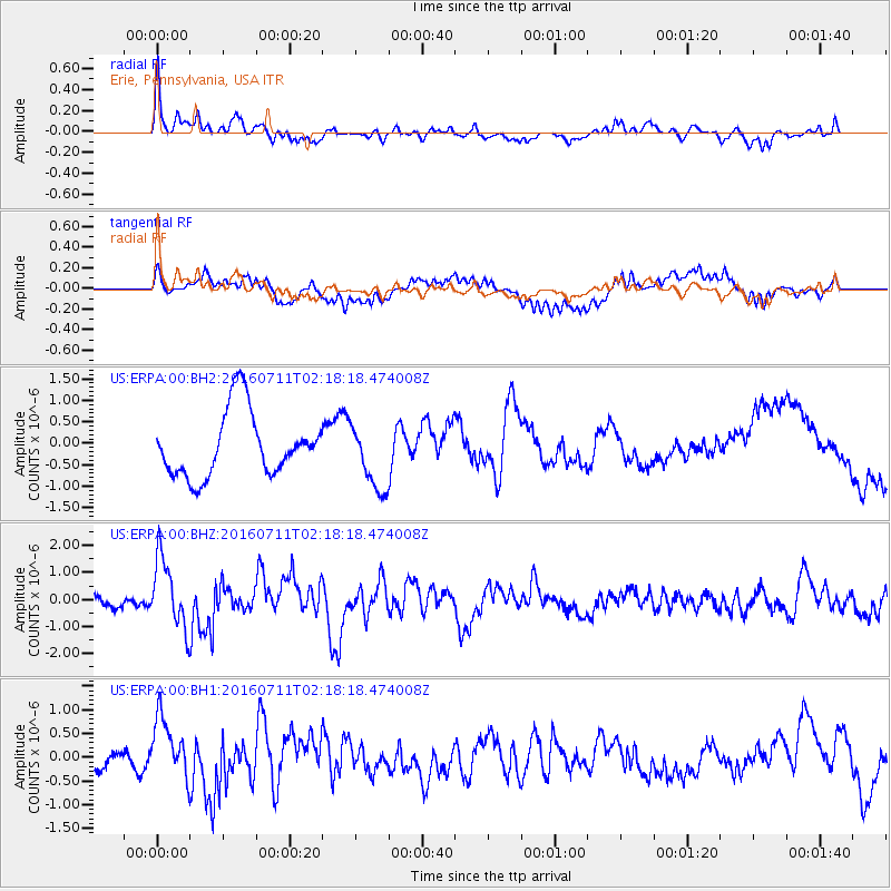
ERPA Erie, Pennsylvania, USA - Earthquake Result Viewer
*The percent match for this event was below the threshold and hence no stack was calculated.
| Earthquake location: |
Near Coast Of Ecuador |
| Earthquake latitude/longitude: |
0.6/-79.7 |
| Earthquake time(UTC): |
2016/07/11 (193) 02:11:04 GMT |
| Earthquake Depth: |
19 km |
| Earthquake Magnitude: |
6.3 MWW, 6.3 MWC, 6.3 MWB |
| Earthquake Catalog/Contributor: |
NEIC PDE/NEIC COMCAT |
|
| Network: |
US United States National Seismic Network |
| Station: |
ERPA Erie, Pennsylvania, USA |
| Lat/Lon: |
42.12 N/79.99 W |
| Elevation: |
306 m |
|
| Distance: |
41.4 deg |
| Az: |
359.633 deg |
| Baz: |
179.507 deg |
| Ray Param: |
$rayparam |
*The percent match for this event was below the threshold and hence was not used in the summary stack. |
|
| Radial Match: |
68.78176 % |
| Radial Bump: |
400 |
| Transverse Match: |
41.70814 % |
| Transverse Bump: |
400 |
| SOD ConfigId: |
1634031 |
| Insert Time: |
2016-07-25 02:35:25.703 +0000 |
| GWidth: |
2.5 |
| Max Bumps: |
400 |
| Tol: |
0.001 |
|
Signal To Noise
| Channel | StoN | STA | LTA |
| US:ERPA:00:BHZ:20160711T02:18:18.474008Z | 7.275519 | 1.2881682E-6 | 1.7705516E-7 |
| US:ERPA:00:BH1:20160711T02:18:18.474008Z | 1.6036227 | 6.7215126E-7 | 4.1914552E-7 |
| US:ERPA:00:BH2:20160711T02:18:18.474008Z | 1.0235728 | 7.6727645E-7 | 7.496061E-7 |
| Arrivals |
| Ps | |
| PpPs | |
| PsPs/PpSs | |


