You are here: Home > Network List > TA - USArray Transportable Network (new EarthScope stations) Stations List
> Station R33M Jennings River, BC, CAN > Earthquake Result Viewer
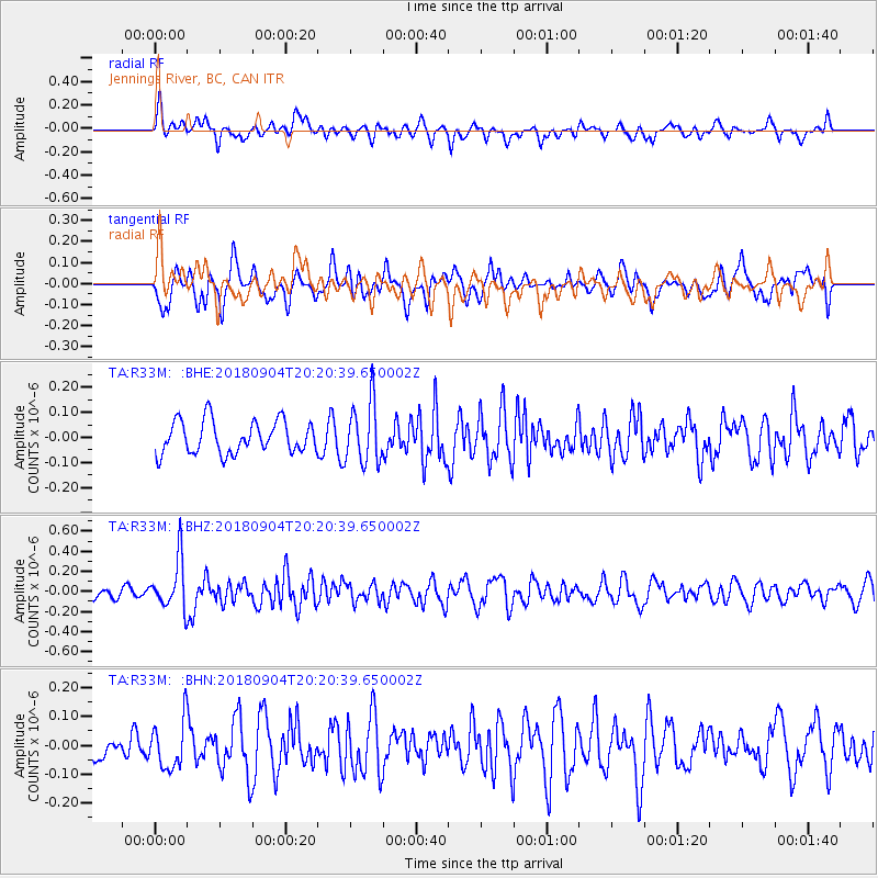
R33M Jennings River, BC, CAN - Earthquake Result Viewer
*The percent match for this event was below the threshold and hence no stack was calculated.
| Earthquake location: |
Near East Coast Of Honshu, Japan |
| Earthquake latitude/longitude: |
36.4/141.5 |
| Earthquake time(UTC): |
2018/09/04 (247) 20:11:19 GMT |
| Earthquake Depth: |
39 km |
| Earthquake Magnitude: |
5.4 Mww |
| Earthquake Catalog/Contributor: |
NEIC PDE/us |
|
| Network: |
TA USArray Transportable Network (new EarthScope stations) |
| Station: |
R33M Jennings River, BC, CAN |
| Lat/Lon: |
59.39 N/130.97 W |
| Elevation: |
1437 m |
|
| Distance: |
58.2 deg |
| Az: |
36.951 deg |
| Baz: |
288.681 deg |
| Ray Param: |
$rayparam |
*The percent match for this event was below the threshold and hence was not used in the summary stack. |
|
| Radial Match: |
53.88543 % |
| Radial Bump: |
400 |
| Transverse Match: |
62.910202 % |
| Transverse Bump: |
400 |
| SOD ConfigId: |
13570011 |
| Insert Time: |
2019-05-01 02:21:20.626 +0000 |
| GWidth: |
2.5 |
| Max Bumps: |
400 |
| Tol: |
0.001 |
|
Signal To Noise
| Channel | StoN | STA | LTA |
| TA:R33M: :BHZ:20180904T20:20:39.650002Z | 3.886654 | 2.4961423E-7 | 6.422342E-8 |
| TA:R33M: :BHN:20180904T20:20:39.650002Z | 2.1030748 | 8.513062E-8 | 4.0479122E-8 |
| TA:R33M: :BHE:20180904T20:20:39.650002Z | 1.9139857 | 1.2385885E-7 | 6.471253E-8 |
| Arrivals |
| Ps | |
| PpPs | |
| PsPs/PpSs | |


