You are here: Home > Network List > TA - USArray Transportable Network (new EarthScope stations) Stations List
> Station J20K Nowitna River, AK, USA > Earthquake Result Viewer
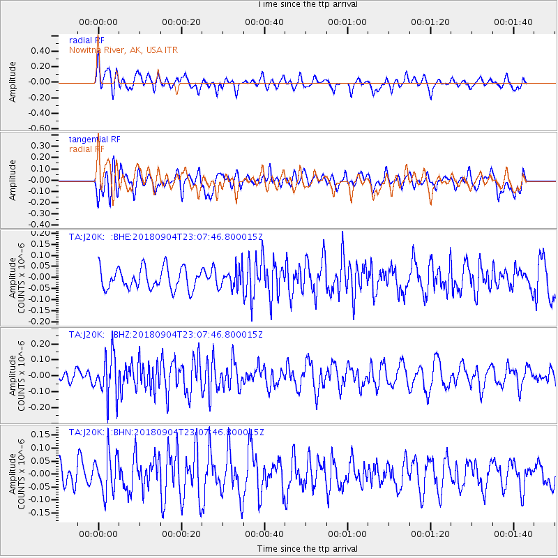
J20K Nowitna River, AK, USA - Earthquake Result Viewer
*The percent match for this event was below the threshold and hence no stack was calculated.
| Earthquake location: |
Ural Mountains Region, Russia |
| Earthquake latitude/longitude: |
54.8/58.0 |
| Earthquake time(UTC): |
2018/09/04 (247) 22:58:19 GMT |
| Earthquake Depth: |
10 km |
| Earthquake Magnitude: |
5.0 Mww |
| Earthquake Catalog/Contributor: |
NEIC PDE/us |
|
| Network: |
TA USArray Transportable Network (new EarthScope stations) |
| Station: |
J20K Nowitna River, AK, USA |
| Lat/Lon: |
64.18 N/154.15 W |
| Elevation: |
314 m |
|
| Distance: |
58.8 deg |
| Az: |
15.805 deg |
| Baz: |
338.9 deg |
| Ray Param: |
$rayparam |
*The percent match for this event was below the threshold and hence was not used in the summary stack. |
|
| Radial Match: |
49.76881 % |
| Radial Bump: |
400 |
| Transverse Match: |
66.2466 % |
| Transverse Bump: |
400 |
| SOD ConfigId: |
13570011 |
| Insert Time: |
2019-05-01 02:30:40.160 +0000 |
| GWidth: |
2.5 |
| Max Bumps: |
400 |
| Tol: |
0.001 |
|
Signal To Noise
| Channel | StoN | STA | LTA |
| TA:J20K: :BHZ:20180904T23:07:46.800015Z | 2.6187413 | 1.3489934E-7 | 5.1513048E-8 |
| TA:J20K: :BHN:20180904T23:07:46.800015Z | 1.6637744 | 7.783023E-8 | 4.6779316E-8 |
| TA:J20K: :BHE:20180904T23:07:46.800015Z | 0.9272362 | 4.386543E-8 | 4.730772E-8 |
| Arrivals |
| Ps | |
| PpPs | |
| PsPs/PpSs | |


