You are here: Home > Network List > TA - USArray Transportable Network (new EarthScope stations) Stations List
> Station U20A Newcomb, NM, USA > Earthquake Result Viewer
U20A Newcomb, NM, USA - Earthquake Result Viewer
| Earthquake location: |
Fiji Islands Region |
| Earthquake latitude/longitude: |
-17.3/-177.3 |
| Earthquake time(UTC): |
2008/07/19 (201) 22:39:52 GMT |
| Earthquake Depth: |
391 km |
| Earthquake Magnitude: |
5.9 MB, 6.4 MW, 6.4 MW |
| Earthquake Catalog/Contributor: |
WHDF/NEIC |
|
| Network: |
TA USArray Transportable Network (new EarthScope stations) |
| Station: |
U20A Newcomb, NM, USA |
| Lat/Lon: |
36.38 N/108.52 W |
| Elevation: |
1682 m |
|
| Distance: |
84.0 deg |
| Az: |
49.155 deg |
| Baz: |
243.546 deg |
| Ray Param: |
0.044723585 |
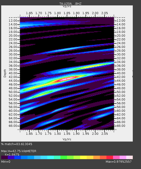
| Estimated Moho Depth: |
42.75 km |
| Estimated Crust Vp/Vs: |
1.85 |
| Assumed Crust Vp: |
6.476 km/s |
| Estimated Crust Vs: |
3.505 km/s |
| Estimated Crust Poisson's Ratio: |
0.29 |
|
| Radial Match: |
83.613045 % |
| Radial Bump: |
400 |
| Transverse Match: |
75.17162 % |
| Transverse Bump: |
400 |
| SOD ConfigId: |
2504 |
| Insert Time: |
2010-03-06 15:11:20.176 +0000 |
| GWidth: |
2.5 |
| Max Bumps: |
400 |
| Tol: |
0.001 |
|

Signal To Noise
| Channel | StoN | STA | LTA |
| TA:U20A: :BHZ:20080719T22:51:09.249011Z | 18.9276 | 1.6893231E-6 | 8.9251834E-8 |
| TA:U20A: :BHN:20080719T22:51:09.249011Z | 3.0362508 | 3.2646224E-7 | 1.075215E-7 |
| TA:U20A: :BHE:20080719T22:51:09.249011Z | 5.331613 | 5.4488396E-7 | 1.021987E-7 |
| Arrivals |
| Ps | 5.7 SECOND |
| PpPs | 18 SECOND |
| PsPs/PpSs | 24 SECOND |


