You are here: Home > Network List > TA - USArray Transportable Network (new EarthScope stations) Stations List
> Station U20A Newcomb, NM, USA > Earthquake Result Viewer
U20A Newcomb, NM, USA - Earthquake Result Viewer
| Earthquake location: |
North Of Severnaya Zemlya |
| Earthquake latitude/longitude: |
83.6/115.2 |
| Earthquake time(UTC): |
2008/08/13 (226) 08:35:02 GMT |
| Earthquake Depth: |
10 km |
| Earthquake Magnitude: |
5.5 MB, 4.7 MS, 5.4 MW, 5.4 MW |
| Earthquake Catalog/Contributor: |
WHDF/NEIC |
|
| Network: |
TA USArray Transportable Network (new EarthScope stations) |
| Station: |
U20A Newcomb, NM, USA |
| Lat/Lon: |
36.38 N/108.52 W |
| Elevation: |
1682 m |
|
| Distance: |
58.5 deg |
| Az: |
40.874 deg |
| Baz: |
354.813 deg |
| Ray Param: |
0.06277484 |
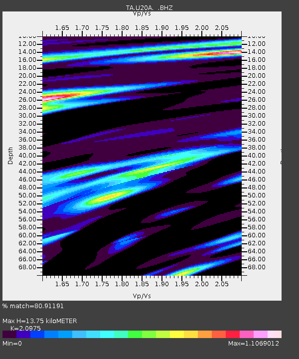
| Estimated Moho Depth: |
13.75 km |
| Estimated Crust Vp/Vs: |
2.10 |
| Assumed Crust Vp: |
6.476 km/s |
| Estimated Crust Vs: |
3.087 km/s |
| Estimated Crust Poisson's Ratio: |
0.35 |
|
| Radial Match: |
80.91191 % |
| Radial Bump: |
400 |
| Transverse Match: |
69.25035 % |
| Transverse Bump: |
400 |
| SOD ConfigId: |
2504 |
| Insert Time: |
2010-03-06 15:11:26.694 +0000 |
| GWidth: |
2.5 |
| Max Bumps: |
400 |
| Tol: |
0.001 |
|

Signal To Noise
| Channel | StoN | STA | LTA |
| TA:U20A: :BHZ:20080813T08:44:27.499014Z | 5.0905848 | 6.1912453E-7 | 1.216215E-7 |
| TA:U20A: :BHN:20080813T08:44:27.499014Z | 1.7169515 | 1.970685E-7 | 1.14778146E-7 |
| TA:U20A: :BHE:20080813T08:44:27.499014Z | 0.99190986 | 1.0584123E-7 | 1.0670449E-7 |
| Arrivals |
| Ps | 2.4 SECOND |
| PpPs | 6.3 SECOND |
| PsPs/PpSs | 8.7 SECOND |


