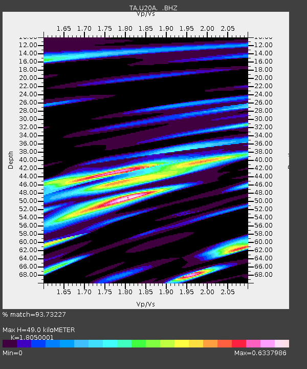
U20A Newcomb, NM, USA - Earthquake Result Viewer

Earthquake location: Kermadec Islands, New Zealand
Earthquake latitude/longitude: -29.8/-177.7
Earthquake time(UTC): 2008/09/29 (273) 15:19:31 GMT
Earthquake Depth: 36 km
Earthquake Magnitude: 6.5 MB, 6.7 MS, 7.0 MW, 7.0 MW
Earthquake Catalog/Contributor: WHDF/NEIC
Network: TA USArray Transportable Network (new EarthScope stations)
Station: U20A Newcomb, NM, USA
Lat/Lon: 36.38 N/108.52 W
Elevation: 1682 m
Distance: 92.4 deg
Az: 49.018 deg
Baz: 234.431 deg
Ray Param: 0.04145257
Estimated Moho Depth: 49.0 km
Estimated Crust Vp/Vs: 1.81
Assumed Crust Vp: 6.476 km/s
Estimated Crust Vs: 3.588 km/s
Estimated Crust Poisson's Ratio: 0.28
Radial Match: 93.73227 %
Radial Bump: 400
Transverse Match: 92.68819 %
Transverse Bump: 400
SOD ConfigId: 2560
Insert Time: 2010-03-06 15:11:36.342 +0000
GWidth: 2.5
Max Bumps: 400
Tol: 0.001

Signal To Noise

ChannelStoNSTALTA
TA:U20A: :BHZ:20080929T15:32:07.199009Z4.35549644.751724E-71.09097186E-7
TA:U20A: :BHN:20080929T15:32:07.199009Z0.7801741.069866E-71.3713172E-7
TA:U20A: :BHE:20080929T15:32:07.199009Z0.985028749.440909E-89.5843994E-8
Arrivals
Ps6.2 SECOND
PpPs21 SECOND
PsPs/PpSs27 SECOND