You are here: Home > Network List > AK - Alaska Regional Network Stations List
> Station MDM Murphy Dome > Earthquake Result Viewer
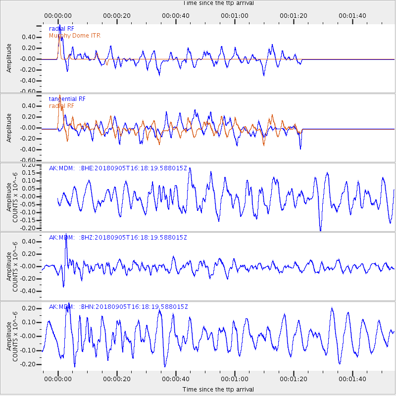
MDM Murphy Dome - Earthquake Result Viewer
*The percent match for this event was below the threshold and hence no stack was calculated.
| Earthquake location: |
South Of Tonga Islands |
| Earthquake latitude/longitude: |
-24.0/-174.8 |
| Earthquake time(UTC): |
2018/09/05 (248) 16:05:46 GMT |
| Earthquake Depth: |
10 km |
| Earthquake Magnitude: |
5.5 mb |
| Earthquake Catalog/Contributor: |
NEIC PDE/us |
|
| Network: |
AK Alaska Regional Network |
| Station: |
MDM Murphy Dome |
| Lat/Lon: |
64.96 N/148.23 W |
| Elevation: |
634 m |
|
| Distance: |
91.0 deg |
| Az: |
10.977 deg |
| Baz: |
204.152 deg |
| Ray Param: |
$rayparam |
*The percent match for this event was below the threshold and hence was not used in the summary stack. |
|
| Radial Match: |
71.64303 % |
| Radial Bump: |
345 |
| Transverse Match: |
62.274055 % |
| Transverse Bump: |
348 |
| SOD ConfigId: |
13570011 |
| Insert Time: |
2019-05-01 02:36:13.183 +0000 |
| GWidth: |
2.5 |
| Max Bumps: |
400 |
| Tol: |
0.001 |
|
Signal To Noise
| Channel | StoN | STA | LTA |
| AK:MDM: :BHZ:20180905T16:18:19.588015Z | 2.6824815 | 1.8358656E-7 | 6.843908E-8 |
| AK:MDM: :BHN:20180905T16:18:19.588015Z | 2.350881 | 1.3508293E-7 | 5.7460554E-8 |
| AK:MDM: :BHE:20180905T16:18:19.588015Z | 1.1350929 | 6.0830615E-8 | 5.3590867E-8 |
| Arrivals |
| Ps | |
| PpPs | |
| PsPs/PpSs | |


