You are here: Home > Network List > TA - USArray Transportable Network (new EarthScope stations) Stations List
> Station U20A Newcomb, NM, USA > Earthquake Result Viewer
U20A Newcomb, NM, USA - Earthquake Result Viewer
| Earthquake location: |
Kermadec Islands Region |
| Earthquake latitude/longitude: |
-27.4/-176.3 |
| Earthquake time(UTC): |
2009/02/18 (049) 21:53:45 GMT |
| Earthquake Depth: |
25 km |
| Earthquake Magnitude: |
6.8 MB, 7.2 MS, 6.9 MW, 6.9 MW |
| Earthquake Catalog/Contributor: |
WHDF/NEIC |
|
| Network: |
TA USArray Transportable Network (new EarthScope stations) |
| Station: |
U20A Newcomb, NM, USA |
| Lat/Lon: |
36.38 N/108.52 W |
| Elevation: |
1682 m |
|
| Distance: |
90.0 deg |
| Az: |
48.354 deg |
| Baz: |
235.391 deg |
| Ray Param: |
0.04170377 |
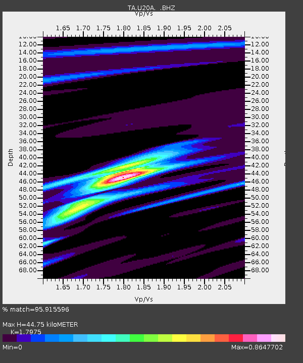
| Estimated Moho Depth: |
44.75 km |
| Estimated Crust Vp/Vs: |
1.80 |
| Assumed Crust Vp: |
6.476 km/s |
| Estimated Crust Vs: |
3.603 km/s |
| Estimated Crust Poisson's Ratio: |
0.28 |
|
| Radial Match: |
95.915596 % |
| Radial Bump: |
261 |
| Transverse Match: |
87.89201 % |
| Transverse Bump: |
400 |
| SOD ConfigId: |
2658 |
| Insert Time: |
2010-03-06 15:11:41.796 +0000 |
| GWidth: |
2.5 |
| Max Bumps: |
400 |
| Tol: |
0.001 |
|

Signal To Noise
| Channel | StoN | STA | LTA |
| TA:U20A: :BHZ:20090218T22:06:10.850002Z | 10.931253 | 2.4755914E-6 | 2.2646911E-7 |
| TA:U20A: :BHN:20090218T22:06:10.850002Z | 1.0711446 | 4.1771494E-7 | 3.8997064E-7 |
| TA:U20A: :BHE:20090218T22:06:10.850002Z | 1.9999611 | 8.383649E-7 | 4.1919057E-7 |
| Arrivals |
| Ps | 5.6 SECOND |
| PpPs | 19 SECOND |
| PsPs/PpSs | 25 SECOND |


