You are here: Home > Network List > TA - USArray Transportable Network (new EarthScope stations) Stations List
> Station U20A Newcomb, NM, USA > Earthquake Result Viewer
U20A Newcomb, NM, USA - Earthquake Result Viewer
| Earthquake location: |
Tonga Islands |
| Earthquake latitude/longitude: |
-20.8/-174.3 |
| Earthquake time(UTC): |
2009/07/30 (211) 20:05:34 GMT |
| Earthquake Depth: |
10 km |
| Earthquake Magnitude: |
5.9 MB, 5.7 MS, 5.8 MW, 5.7 MW |
| Earthquake Catalog/Contributor: |
WHDF/NEIC |
|
| Network: |
TA USArray Transportable Network (new EarthScope stations) |
| Station: |
U20A Newcomb, NM, USA |
| Lat/Lon: |
36.38 N/108.52 W |
| Elevation: |
1682 m |
|
| Distance: |
84.2 deg |
| Az: |
47.692 deg |
| Baz: |
238.99 deg |
| Ray Param: |
0.045661088 |
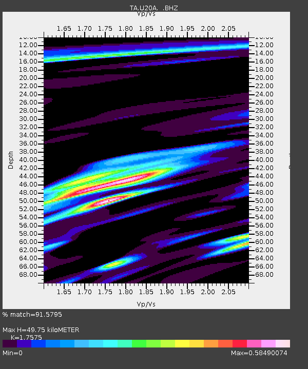
| Estimated Moho Depth: |
49.75 km |
| Estimated Crust Vp/Vs: |
1.76 |
| Assumed Crust Vp: |
6.476 km/s |
| Estimated Crust Vs: |
3.685 km/s |
| Estimated Crust Poisson's Ratio: |
0.26 |
|
| Radial Match: |
91.5795 % |
| Radial Bump: |
400 |
| Transverse Match: |
92.13878 % |
| Transverse Bump: |
400 |
| SOD ConfigId: |
2622 |
| Insert Time: |
2010-03-06 15:11:44.232 +0000 |
| GWidth: |
2.5 |
| Max Bumps: |
400 |
| Tol: |
0.001 |
|

Signal To Noise
| Channel | StoN | STA | LTA |
| TA:U20A: :BHZ:20090730T20:17:34.87501Z | 7.2564487 | 6.49728E-7 | 8.953801E-8 |
| TA:U20A: :BHN:20090730T20:17:34.87501Z | 1.0718856 | 1.02618046E-7 | 9.5736006E-8 |
| TA:U20A: :BHE:20090730T20:17:34.87501Z | 1.9086707 | 2.0959097E-7 | 1.0980992E-7 |
| Arrivals |
| Ps | 6.0 SECOND |
| PpPs | 21 SECOND |
| PsPs/PpSs | 27 SECOND |


