You are here: Home > Network List > CI - Caltech Regional Seismic Network Stations List
> Station MPM Manuel Prospect Mine, California, USA > Earthquake Result Viewer
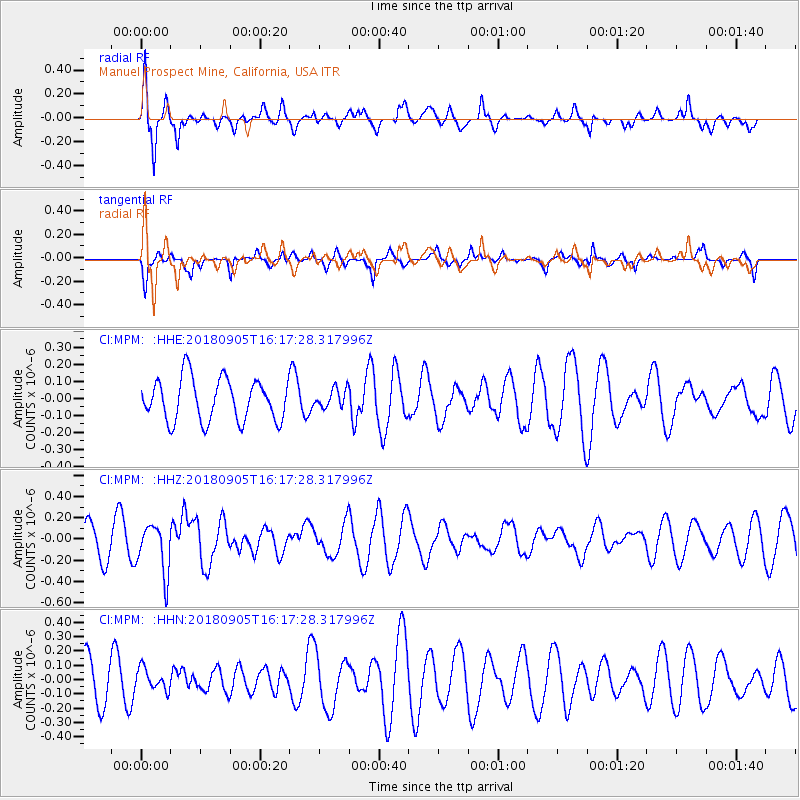
MPM Manuel Prospect Mine, California, USA - Earthquake Result Viewer
*The percent match for this event was below the threshold and hence no stack was calculated.
| Earthquake location: |
South Of Tonga Islands |
| Earthquake latitude/longitude: |
-24.0/-174.8 |
| Earthquake time(UTC): |
2018/09/05 (248) 16:05:46 GMT |
| Earthquake Depth: |
10 km |
| Earthquake Magnitude: |
5.5 mb |
| Earthquake Catalog/Contributor: |
NEIC PDE/us |
|
| Network: |
CI Caltech Regional Seismic Network |
| Station: |
MPM Manuel Prospect Mine, California, USA |
| Lat/Lon: |
36.06 N/117.49 W |
| Elevation: |
185 m |
|
| Distance: |
80.6 deg |
| Az: |
43.727 deg |
| Baz: |
231.274 deg |
| Ray Param: |
$rayparam |
*The percent match for this event was below the threshold and hence was not used in the summary stack. |
|
| Radial Match: |
62.413208 % |
| Radial Bump: |
400 |
| Transverse Match: |
54.2337 % |
| Transverse Bump: |
283 |
| SOD ConfigId: |
13570011 |
| Insert Time: |
2019-05-01 02:38:06.152 +0000 |
| GWidth: |
2.5 |
| Max Bumps: |
400 |
| Tol: |
0.001 |
|
Signal To Noise
| Channel | StoN | STA | LTA |
| CI:MPM: :HHZ:20180905T16:17:28.317996Z | 1.700145 | 2.2814815E-7 | 1.3419336E-7 |
| CI:MPM: :HHN:20180905T16:17:28.317996Z | 0.49190685 | 7.615625E-8 | 1.5481844E-7 |
| CI:MPM: :HHE:20180905T16:17:28.317996Z | 0.40841022 | 5.0806303E-8 | 1.2440017E-7 |
| Arrivals |
| Ps | |
| PpPs | |
| PsPs/PpSs | |


