You are here: Home > Network List > TA - USArray Transportable Network (new EarthScope stations) Stations List
> Station U20A Newcomb, NM, USA > Earthquake Result Viewer
U20A Newcomb, NM, USA - Earthquake Result Viewer
| Earthquake location: |
Kermadec Islands Region |
| Earthquake latitude/longitude: |
-31.5/-178.8 |
| Earthquake time(UTC): |
2009/05/16 (136) 00:53:52 GMT |
| Earthquake Depth: |
55 km |
| Earthquake Magnitude: |
6.1 MB, 6.5 MW, 6.3 MW |
| Earthquake Catalog/Contributor: |
WHDF/NEIC |
|
| Network: |
TA USArray Transportable Network (new EarthScope stations) |
| Station: |
U20A Newcomb, NM, USA |
| Lat/Lon: |
36.38 N/108.52 W |
| Elevation: |
1682 m |
|
| Distance: |
94.3 deg |
| Az: |
49.622 deg |
| Baz: |
233.72 deg |
| Ray Param: |
0.041053105 |
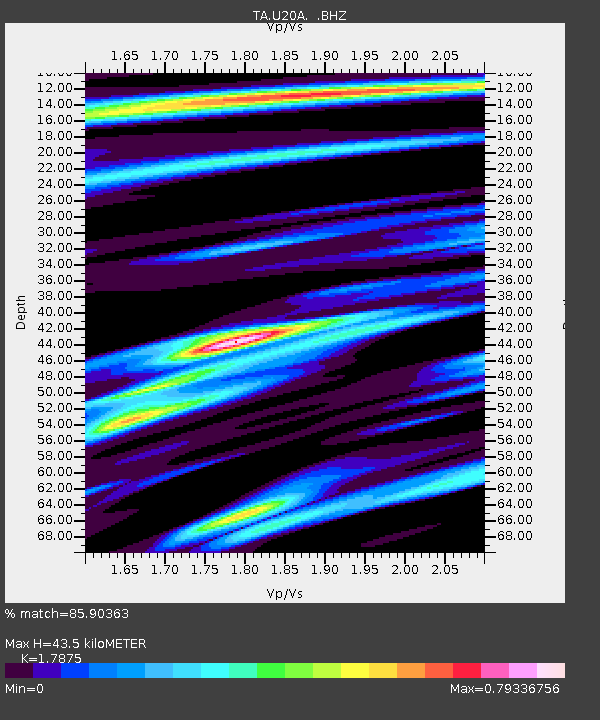
| Estimated Moho Depth: |
43.5 km |
| Estimated Crust Vp/Vs: |
1.79 |
| Assumed Crust Vp: |
6.476 km/s |
| Estimated Crust Vs: |
3.623 km/s |
| Estimated Crust Poisson's Ratio: |
0.27 |
|
| Radial Match: |
85.90363 % |
| Radial Bump: |
400 |
| Transverse Match: |
78.91962 % |
| Transverse Bump: |
400 |
| SOD ConfigId: |
2760 |
| Insert Time: |
2010-03-06 15:12:20.668 +0000 |
| GWidth: |
2.5 |
| Max Bumps: |
400 |
| Tol: |
0.001 |
|

Signal To Noise
| Channel | StoN | STA | LTA |
| TA:U20A: :BHZ:20090516T01:06:34.75001Z | 8.394547 | 9.138427E-7 | 1.0886146E-7 |
| TA:U20A: :BHN:20090516T01:06:34.75001Z | 1.4392408 | 1.6051715E-7 | 1.1152904E-7 |
| TA:U20A: :BHE:20090516T01:06:34.75001Z | 2.1099644 | 3.1448482E-7 | 1.4904745E-7 |
| Arrivals |
| Ps | 5.4 SECOND |
| PpPs | 18 SECOND |
| PsPs/PpSs | 24 SECOND |


