You are here: Home > Network List > AK - Alaska Regional Network Stations List
> Station WAT1 Susitna Watana 1, AK, USA > Earthquake Result Viewer
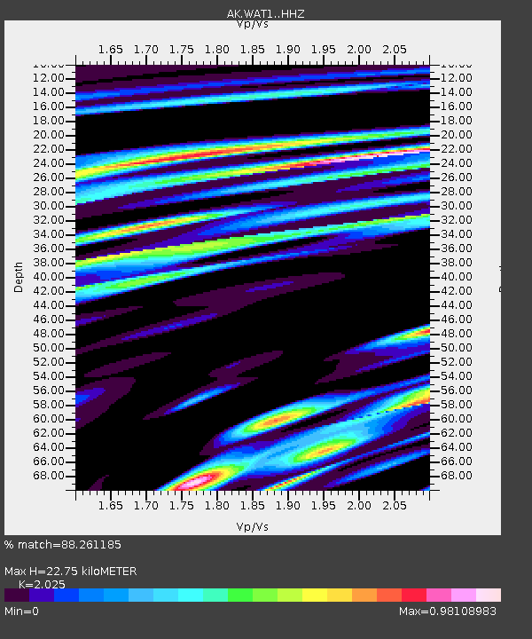
WAT1 Susitna Watana 1, AK, USA - Earthquake Result Viewer
| Earthquake location: |
Hokkaido, Japan Region |
| Earthquake latitude/longitude: |
42.7/141.9 |
| Earthquake time(UTC): |
2018/09/05 (248) 18:07:58 GMT |
| Earthquake Depth: |
31 km |
| Earthquake Magnitude: |
6.6 Mww |
| Earthquake Catalog/Contributor: |
NEIC PDE/us |
|
| Network: |
AK Alaska Regional Network |
| Station: |
WAT1 Susitna Watana 1, AK, USA |
| Lat/Lon: |
62.83 N/148.55 W |
| Elevation: |
722 m |
|
| Distance: |
44.0 deg |
| Az: |
38.211 deg |
| Baz: |
276.698 deg |
| Ray Param: |
0.07209978 |
| Estimated Moho Depth: |
22.75 km |
| Estimated Crust Vp/Vs: |
2.03 |
| Assumed Crust Vp: |
6.566 km/s |
| Estimated Crust Vs: |
3.243 km/s |
| Estimated Crust Poisson's Ratio: |
0.34 |
|
| Radial Match: |
88.261185 % |
| Radial Bump: |
400 |
| Transverse Match: |
85.585236 % |
| Transverse Bump: |
400 |
| SOD ConfigId: |
13570011 |
| Insert Time: |
2019-05-01 02:45:07.714 +0000 |
| GWidth: |
2.5 |
| Max Bumps: |
400 |
| Tol: |
0.001 |
|

Signal To Noise
| Channel | StoN | STA | LTA |
| AK:WAT1: :HHZ:20180905T18:15:33.197992Z | 3.9767222 | 6.0200364E-7 | 1.5138187E-7 |
| AK:WAT1: :HHN:20180905T18:15:33.197992Z | 2.0477023 | 1.5858707E-7 | 7.744635E-8 |
| AK:WAT1: :HHE:20180905T18:15:33.197992Z | 1.1500103 | 4.4972563E-7 | 3.9106226E-7 |
| Arrivals |
| Ps | 3.8 SECOND |
| PpPs | 9.9 SECOND |
| PsPs/PpSs | 14 SECOND |


