You are here: Home > Network List > AV - Alaska Volcano Observatory Stations List
> Station WACK Chichokna Glacier, Wrangell, Alaska > Earthquake Result Viewer
WACK Chichokna Glacier, Wrangell, Alaska - Earthquake Result Viewer
| Earthquake location: |
Hokkaido, Japan Region |
| Earthquake latitude/longitude: |
42.7/141.9 |
| Earthquake time(UTC): |
2018/09/05 (248) 18:07:58 GMT |
| Earthquake Depth: |
31 km |
| Earthquake Magnitude: |
6.6 Mww |
| Earthquake Catalog/Contributor: |
NEIC PDE/us |
|
| Network: |
AV Alaska Volcano Observatory |
| Station: |
WACK Chichokna Glacier, Wrangell, Alaska |
| Lat/Lon: |
61.99 N/144.33 W |
| Elevation: |
2280 m |
|
| Distance: |
46.1 deg |
| Az: |
38.966 deg |
| Baz: |
280.967 deg |
| Ray Param: |
0.070785746 |
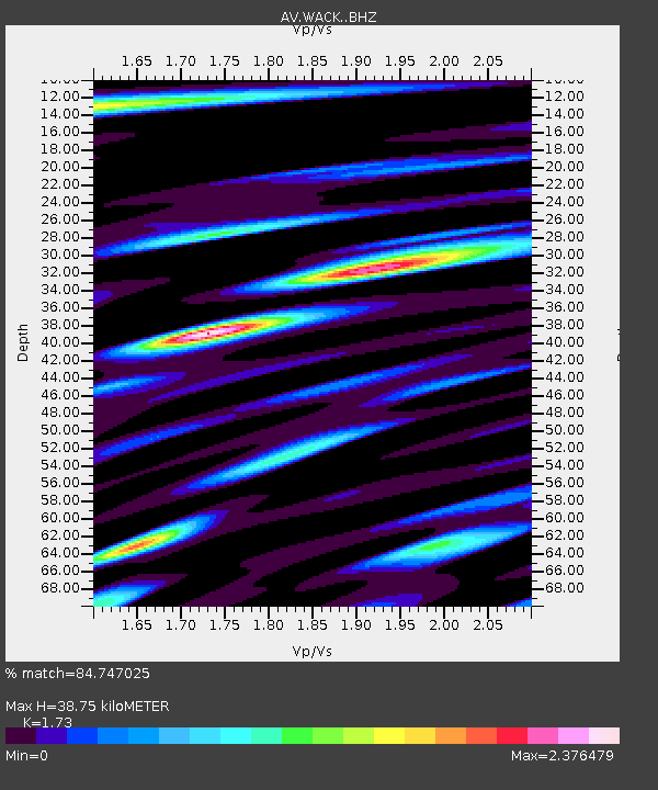
| Estimated Moho Depth: |
38.75 km |
| Estimated Crust Vp/Vs: |
1.73 |
| Assumed Crust Vp: |
6.566 km/s |
| Estimated Crust Vs: |
3.795 km/s |
| Estimated Crust Poisson's Ratio: |
0.25 |
|
| Radial Match: |
84.747025 % |
| Radial Bump: |
400 |
| Transverse Match: |
91.77752 % |
| Transverse Bump: |
400 |
| SOD ConfigId: |
13570011 |
| Insert Time: |
2019-05-01 02:45:45.811 +0000 |
| GWidth: |
2.5 |
| Max Bumps: |
400 |
| Tol: |
0.001 |
|

Signal To Noise
| Channel | StoN | STA | LTA |
| AV:WACK: :BHZ:20180905T18:15:49.619989Z | 1.4882762 | 1.2852708E-7 | 8.6359684E-8 |
| AV:WACK: :BHN:20180905T18:15:49.619989Z | 1.8016831 | 1.6333915E-7 | 9.06592E-8 |
| AV:WACK: :BHE:20180905T18:15:49.619989Z | 1.4912441 | 1.8969428E-7 | 1.2720538E-7 |
| Arrivals |
| Ps | 4.6 SECOND |
| PpPs | 15 SECOND |
| PsPs/PpSs | 20 SECOND |


