You are here: Home > Network List > AV - Alaska Volcano Observatory Stations List
> Station WEBT Beartrack Creek, Westdahl Peak, Alaska > Earthquake Result Viewer
WEBT Beartrack Creek, Westdahl Peak, Alaska - Earthquake Result Viewer
| Earthquake location: |
Hokkaido, Japan Region |
| Earthquake latitude/longitude: |
42.7/141.9 |
| Earthquake time(UTC): |
2018/09/05 (248) 18:07:58 GMT |
| Earthquake Depth: |
31 km |
| Earthquake Magnitude: |
6.6 Mww |
| Earthquake Catalog/Contributor: |
NEIC PDE/us |
|
| Network: |
AV Alaska Volcano Observatory |
| Station: |
WEBT Beartrack Creek, Westdahl Peak, Alaska |
| Lat/Lon: |
54.59 N/164.76 W |
| Elevation: |
467 m |
|
| Distance: |
36.3 deg |
| Az: |
52.018 deg |
| Baz: |
273.409 deg |
| Ray Param: |
0.0766957 |
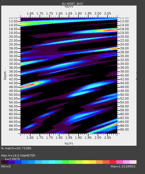
| Estimated Moho Depth: |
16.0 km |
| Estimated Crust Vp/Vs: |
2.10 |
| Assumed Crust Vp: |
5.989 km/s |
| Estimated Crust Vs: |
2.855 km/s |
| Estimated Crust Poisson's Ratio: |
0.35 |
|
| Radial Match: |
84.73398 % |
| Radial Bump: |
400 |
| Transverse Match: |
61.954605 % |
| Transverse Bump: |
400 |
| SOD ConfigId: |
13570011 |
| Insert Time: |
2019-05-01 02:45:46.339 +0000 |
| GWidth: |
2.5 |
| Max Bumps: |
400 |
| Tol: |
0.001 |
|

Signal To Noise
| Channel | StoN | STA | LTA |
| AV:WEBT: :BHZ:20180905T18:14:29.200006Z | 2.778022 | 8.786593E-7 | 3.1628954E-7 |
| AV:WEBT: :BHN:20180905T18:14:29.200006Z | 0.8040552 | 3.8059324E-7 | 4.7334217E-7 |
| AV:WEBT: :BHE:20180905T18:14:29.200006Z | 1.4571635 | 5.8121E-7 | 3.9886396E-7 |
| Arrivals |
| Ps | 3.1 SECOND |
| PpPs | 7.8 SECOND |
| PsPs/PpSs | 11 SECOND |


