You are here: Home > Network List > TA - USArray Transportable Network (new EarthScope stations) Stations List
> Station C21K Knifeblade Ridge, AK, USA > Earthquake Result Viewer
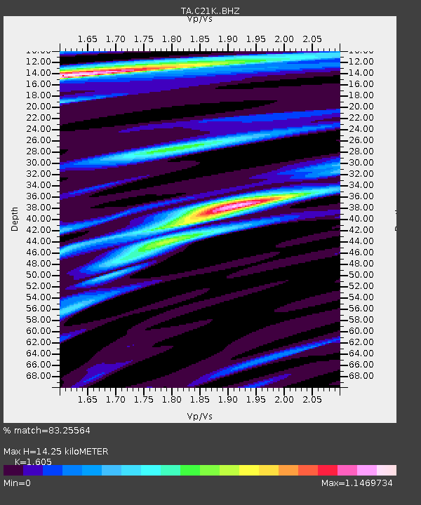
C21K Knifeblade Ridge, AK, USA - Earthquake Result Viewer
| Earthquake location: |
Hokkaido, Japan Region |
| Earthquake latitude/longitude: |
42.7/141.9 |
| Earthquake time(UTC): |
2018/09/05 (248) 18:07:58 GMT |
| Earthquake Depth: |
31 km |
| Earthquake Magnitude: |
6.6 Mww |
| Earthquake Catalog/Contributor: |
NEIC PDE/us |
|
| Network: |
TA USArray Transportable Network (new EarthScope stations) |
| Station: |
C21K Knifeblade Ridge, AK, USA |
| Lat/Lon: |
69.16 N/154.78 W |
| Elevation: |
409 m |
|
| Distance: |
41.4 deg |
| Az: |
28.884 deg |
| Baz: |
264.143 deg |
| Ray Param: |
0.0737284 |
| Estimated Moho Depth: |
14.25 km |
| Estimated Crust Vp/Vs: |
1.61 |
| Assumed Crust Vp: |
6.221 km/s |
| Estimated Crust Vs: |
3.876 km/s |
| Estimated Crust Poisson's Ratio: |
0.18 |
|
| Radial Match: |
83.25564 % |
| Radial Bump: |
400 |
| Transverse Match: |
80.226234 % |
| Transverse Bump: |
400 |
| SOD ConfigId: |
13570011 |
| Insert Time: |
2019-05-01 02:51:24.526 +0000 |
| GWidth: |
2.5 |
| Max Bumps: |
400 |
| Tol: |
0.001 |
|

Signal To Noise
| Channel | StoN | STA | LTA |
| TA:C21K: :BHZ:20180905T18:15:12.149988Z | 4.0379696 | 7.274801E-7 | 1.8015989E-7 |
| TA:C21K: :BHN:20180905T18:15:12.149988Z | 1.3798326 | 1.1813828E-7 | 8.5617835E-8 |
| TA:C21K: :BHE:20180905T18:15:12.149988Z | 2.5752141 | 2.4105384E-7 | 9.360536E-8 |
| Arrivals |
| Ps | 1.5 SECOND |
| PpPs | 5.6 SECOND |
| PsPs/PpSs | 7.0 SECOND |


