You are here: Home > Network List > TA - USArray Transportable Network (new EarthScope stations) Stations List
> Station D20K Etivluk River, AK, USA > Earthquake Result Viewer
D20K Etivluk River, AK, USA - Earthquake Result Viewer
| Earthquake location: |
Hokkaido, Japan Region |
| Earthquake latitude/longitude: |
42.7/141.9 |
| Earthquake time(UTC): |
2018/09/05 (248) 18:07:58 GMT |
| Earthquake Depth: |
31 km |
| Earthquake Magnitude: |
6.6 Mww |
| Earthquake Catalog/Contributor: |
NEIC PDE/us |
|
| Network: |
TA USArray Transportable Network (new EarthScope stations) |
| Station: |
D20K Etivluk River, AK, USA |
| Lat/Lon: |
68.71 N/156.61 W |
| Elevation: |
577 m |
|
| Distance: |
40.7 deg |
| Az: |
29.443 deg |
| Baz: |
262.858 deg |
| Ray Param: |
0.07416757 |
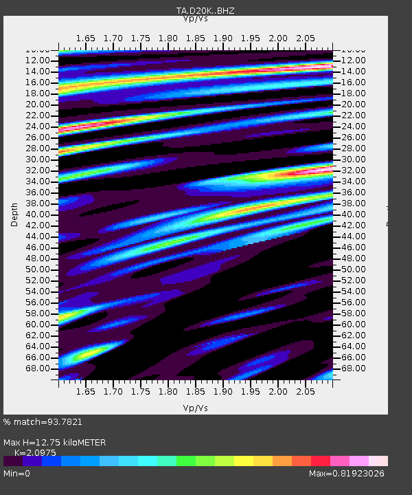
| Estimated Moho Depth: |
12.75 km |
| Estimated Crust Vp/Vs: |
2.10 |
| Assumed Crust Vp: |
6.221 km/s |
| Estimated Crust Vs: |
2.966 km/s |
| Estimated Crust Poisson's Ratio: |
0.35 |
|
| Radial Match: |
93.7821 % |
| Radial Bump: |
400 |
| Transverse Match: |
89.148705 % |
| Transverse Bump: |
400 |
| SOD ConfigId: |
13570011 |
| Insert Time: |
2019-05-01 02:51:29.736 +0000 |
| GWidth: |
2.5 |
| Max Bumps: |
400 |
| Tol: |
0.001 |
|

Signal To Noise
| Channel | StoN | STA | LTA |
| TA:D20K: :BHZ:20180905T18:15:06.325006Z | 11.211578 | 1.2053891E-6 | 1.0751288E-7 |
| TA:D20K: :BHN:20180905T18:15:06.325006Z | 2.4870205 | 3.234313E-7 | 1.300477E-7 |
| TA:D20K: :BHE:20180905T18:15:06.325006Z | 5.4742985 | 5.172457E-7 | 9.448621E-8 |
| Arrivals |
| Ps | 2.4 SECOND |
| PpPs | 6.0 SECOND |
| PsPs/PpSs | 8.4 SECOND |


