You are here: Home > Network List > TA - USArray Transportable Network (new EarthScope stations) Stations List
> Station G27K Doyon Strip, AK, USA > Earthquake Result Viewer
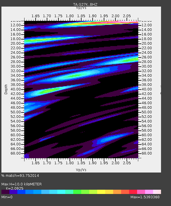
G27K Doyon Strip, AK, USA - Earthquake Result Viewer
| Earthquake location: |
Hokkaido, Japan Region |
| Earthquake latitude/longitude: |
42.7/141.9 |
| Earthquake time(UTC): |
2018/09/05 (248) 18:07:58 GMT |
| Earthquake Depth: |
31 km |
| Earthquake Magnitude: |
6.6 Mww |
| Earthquake Catalog/Contributor: |
NEIC PDE/us |
|
| Network: |
TA USArray Transportable Network (new EarthScope stations) |
| Station: |
G27K Doyon Strip, AK, USA |
| Lat/Lon: |
66.81 N/141.65 W |
| Elevation: |
686 m |
|
| Distance: |
46.4 deg |
| Az: |
32.089 deg |
| Baz: |
278.622 deg |
| Ray Param: |
0.07058603 |
| Estimated Moho Depth: |
10.0 km |
| Estimated Crust Vp/Vs: |
2.09 |
| Assumed Crust Vp: |
6.577 km/s |
| Estimated Crust Vs: |
3.143 km/s |
| Estimated Crust Poisson's Ratio: |
0.35 |
|
| Radial Match: |
93.752014 % |
| Radial Bump: |
400 |
| Transverse Match: |
83.417755 % |
| Transverse Bump: |
400 |
| SOD ConfigId: |
13570011 |
| Insert Time: |
2019-05-01 02:51:57.728 +0000 |
| GWidth: |
2.5 |
| Max Bumps: |
400 |
| Tol: |
0.001 |
|

Signal To Noise
| Channel | StoN | STA | LTA |
| TA:G27K: :BHZ:20180905T18:15:52.175012Z | 2.4228404 | 2.0888659E-7 | 8.6215586E-8 |
| TA:G27K: :BHN:20180905T18:15:52.175012Z | 0.6199847 | 4.3274728E-8 | 6.9799675E-8 |
| TA:G27K: :BHE:20180905T18:15:52.175012Z | 1.2224302 | 1.3745354E-7 | 1.12442855E-7 |
| Arrivals |
| Ps | 1.8 SECOND |
| PpPs | 4.4 SECOND |
| PsPs/PpSs | 6.2 SECOND |


