You are here: Home > Network List > TA - USArray Transportable Network (new EarthScope stations) Stations List
> Station P29M Windy Craggy, BC, CAN > Earthquake Result Viewer
P29M Windy Craggy, BC, CAN - Earthquake Result Viewer

| Earthquake location: |
Hokkaido, Japan Region |
| Earthquake latitude/longitude: |
42.7/141.9 |
| Earthquake time(UTC): |
2018/09/05 (248) 18:07:58 GMT |
| Earthquake Depth: |
31 km |
| Earthquake Magnitude: |
6.6 Mww |
| Earthquake Catalog/Contributor: |
NEIC PDE/us |
|
| Network: |
TA USArray Transportable Network (new EarthScope stations) |
| Station: |
P29M Windy Craggy, BC, CAN |
| Lat/Lon: |
59.63 N/137.74 W |
| Elevation: |
679 m |
|
| Distance: |
49.8 deg |
| Az: |
40.952 deg |
| Baz: |
288.046 deg |
| Ray Param: |
0.06839071 |
| Estimated Moho Depth: |
13.5 km |
| Estimated Crust Vp/Vs: |
1.61 |
| Assumed Crust Vp: |
6.566 km/s |
| Estimated Crust Vs: |
4.078 km/s |
| Estimated Crust Poisson's Ratio: |
0.19 |
|
| Radial Match: |
96.85317 % |
| Radial Bump: |
400 |
| Transverse Match: |
93.10004 % |
| Transverse Bump: |
400 |
| SOD ConfigId: |
13570011 |
| Insert Time: |
2019-05-01 02:52:32.548 +0000 |
| GWidth: |
2.5 |
| Max Bumps: |
400 |
| Tol: |
0.001 |
|
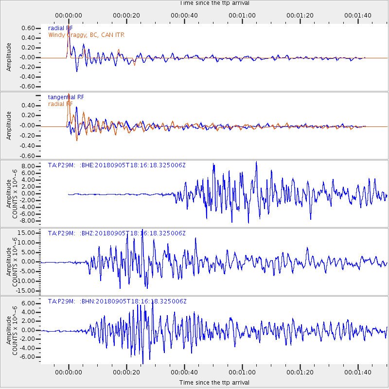
Signal To Noise
| Channel | StoN | STA | LTA |
| TA:P29M: :BHZ:20180905T18:16:18.325006Z | 2.5418992 | 2.4353312E-7 | 9.580754E-8 |
| TA:P29M: :BHN:20180905T18:16:18.325006Z | 1.1294537 | 9.465274E-8 | 8.380401E-8 |
| TA:P29M: :BHE:20180905T18:16:18.325006Z | 1.8934008 | 1.5156807E-7 | 8.005071E-8 |
| Arrivals |
| Ps | 1.3 SECOND |
| PpPs | 5.0 SECOND |
| PsPs/PpSs | 6.4 SECOND |


