You are here: Home > Network List > TA - USArray Transportable Network (new EarthScope stations) Stations List
> Station Q20K Shuyak Island, AK, USA > Earthquake Result Viewer
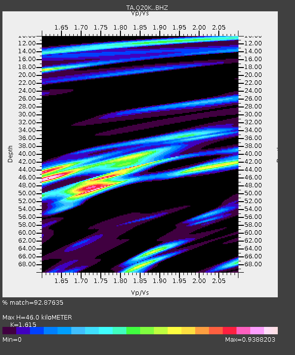
Q20K Shuyak Island, AK, USA - Earthquake Result Viewer
| Earthquake location: |
Hokkaido, Japan Region |
| Earthquake latitude/longitude: |
42.7/141.9 |
| Earthquake time(UTC): |
2018/09/05 (248) 18:07:58 GMT |
| Earthquake Depth: |
31 km |
| Earthquake Magnitude: |
6.6 Mww |
| Earthquake Catalog/Contributor: |
NEIC PDE/us |
|
| Network: |
TA USArray Transportable Network (new EarthScope stations) |
| Station: |
Q20K Shuyak Island, AK, USA |
| Lat/Lon: |
58.61 N/152.39 W |
| Elevation: |
180 m |
|
| Distance: |
42.7 deg |
| Az: |
44.677 deg |
| Baz: |
278.051 deg |
| Ray Param: |
0.07295188 |
| Estimated Moho Depth: |
46.0 km |
| Estimated Crust Vp/Vs: |
1.62 |
| Assumed Crust Vp: |
5.989 km/s |
| Estimated Crust Vs: |
3.708 km/s |
| Estimated Crust Poisson's Ratio: |
0.19 |
|
| Radial Match: |
92.87635 % |
| Radial Bump: |
346 |
| Transverse Match: |
86.47719 % |
| Transverse Bump: |
400 |
| SOD ConfigId: |
13570011 |
| Insert Time: |
2019-05-01 02:52:34.681 +0000 |
| GWidth: |
2.5 |
| Max Bumps: |
400 |
| Tol: |
0.001 |
|

Signal To Noise
| Channel | StoN | STA | LTA |
| TA:Q20K: :BHZ:20180905T18:15:22.475Z | 2.7116213 | 9.12027E-7 | 3.363401E-7 |
| TA:Q20K: :BHN:20180905T18:15:22.475Z | 1.0778865 | 2.025012E-7 | 1.8786878E-7 |
| TA:Q20K: :BHE:20180905T18:15:22.475Z | 1.4604648 | 4.7017969E-7 | 3.219384E-7 |
| Arrivals |
| Ps | 5.0 SECOND |
| PpPs | 19 SECOND |
| PsPs/PpSs | 24 SECOND |


