You are here: Home > Network List > GS - US Geological Survey Networks Stations List
> Station KAN10 Keim Farm > Earthquake Result Viewer
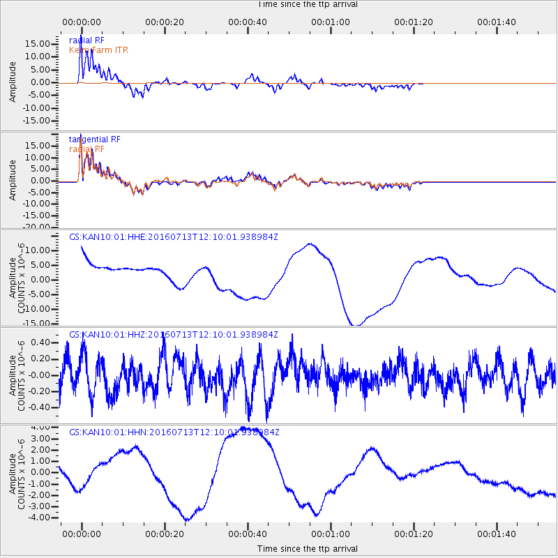
KAN10 Keim Farm - Earthquake Result Viewer
*The percent match for this event was below the threshold and hence no stack was calculated.
| Earthquake location: |
Kermadec Islands Region |
| Earthquake latitude/longitude: |
-28.2/-176.3 |
| Earthquake time(UTC): |
2016/07/13 (195) 11:56:58 GMT |
| Earthquake Depth: |
17 km |
| Earthquake Magnitude: |
5.7 MB |
| Earthquake Catalog/Contributor: |
NEIC PDE/NEIC COMCAT |
|
| Network: |
GS US Geological Survey Networks |
| Station: |
KAN10 Keim Farm |
| Lat/Lon: |
37.12 N/98.10 W |
| Elevation: |
417 m |
|
| Distance: |
98.0 deg |
| Az: |
52.195 deg |
| Baz: |
240.728 deg |
| Ray Param: |
$rayparam |
*The percent match for this event was below the threshold and hence was not used in the summary stack. |
|
| Radial Match: |
52.918427 % |
| Radial Bump: |
318 |
| Transverse Match: |
58.395893 % |
| Transverse Bump: |
373 |
| SOD ConfigId: |
1634031 |
| Insert Time: |
2016-07-27 11:57:42.170 +0000 |
| GWidth: |
2.5 |
| Max Bumps: |
400 |
| Tol: |
0.001 |
|
Signal To Noise
| Channel | StoN | STA | LTA |
| GS:KAN10:01:HHZ:20160713T12:10:01.938984Z | 1.4656577 | 2.4247478E-7 | 1.6543753E-7 |
| GS:KAN10:01:HHN:20160713T12:10:01.938984Z | 1.582222 | 1.2492459E-6 | 7.895516E-7 |
| GS:KAN10:01:HHE:20160713T12:10:01.938984Z | 1.6346226 | 4.403746E-6 | 2.6940447E-6 |
| Arrivals |
| Ps | |
| PpPs | |
| PsPs/PpSs | |


