You are here: Home > Network List > TA - USArray Transportable Network (new EarthScope stations) Stations List
> Station D25K Kavik River, AK, USA > Earthquake Result Viewer
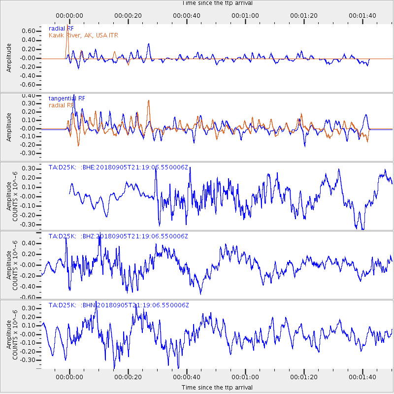
D25K Kavik River, AK, USA - Earthquake Result Viewer
*The percent match for this event was below the threshold and hence no stack was calculated.
| Earthquake location: |
Hokkaido, Japan Region |
| Earthquake latitude/longitude: |
42.7/142.0 |
| Earthquake time(UTC): |
2018/09/05 (248) 21:11:29 GMT |
| Earthquake Depth: |
36 km |
| Earthquake Magnitude: |
5.4 Mww |
| Earthquake Catalog/Contributor: |
NEIC PDE/us |
|
| Network: |
TA USArray Transportable Network (new EarthScope stations) |
| Station: |
D25K Kavik River, AK, USA |
| Lat/Lon: |
69.32 N/146.38 W |
| Elevation: |
770 m |
|
| Distance: |
44.5 deg |
| Az: |
28.773 deg |
| Baz: |
271.885 deg |
| Ray Param: |
$rayparam |
*The percent match for this event was below the threshold and hence was not used in the summary stack. |
|
| Radial Match: |
68.87719 % |
| Radial Bump: |
400 |
| Transverse Match: |
69.941795 % |
| Transverse Bump: |
400 |
| SOD ConfigId: |
13570011 |
| Insert Time: |
2019-05-01 03:01:29.297 +0000 |
| GWidth: |
2.5 |
| Max Bumps: |
400 |
| Tol: |
0.001 |
|
Signal To Noise
| Channel | StoN | STA | LTA |
| TA:D25K: :BHZ:20180905T21:19:06.550006Z | 1.7083755 | 1.989254E-7 | 1.1644127E-7 |
| TA:D25K: :BHN:20180905T21:19:06.550006Z | 0.7602428 | 8.5003286E-8 | 1.1181071E-7 |
| TA:D25K: :BHE:20180905T21:19:06.550006Z | 1.7957832 | 1.5127587E-7 | 8.42395E-8 |
| Arrivals |
| Ps | |
| PpPs | |
| PsPs/PpSs | |


