You are here: Home > Network List > TA - USArray Transportable Network (new EarthScope stations) Stations List
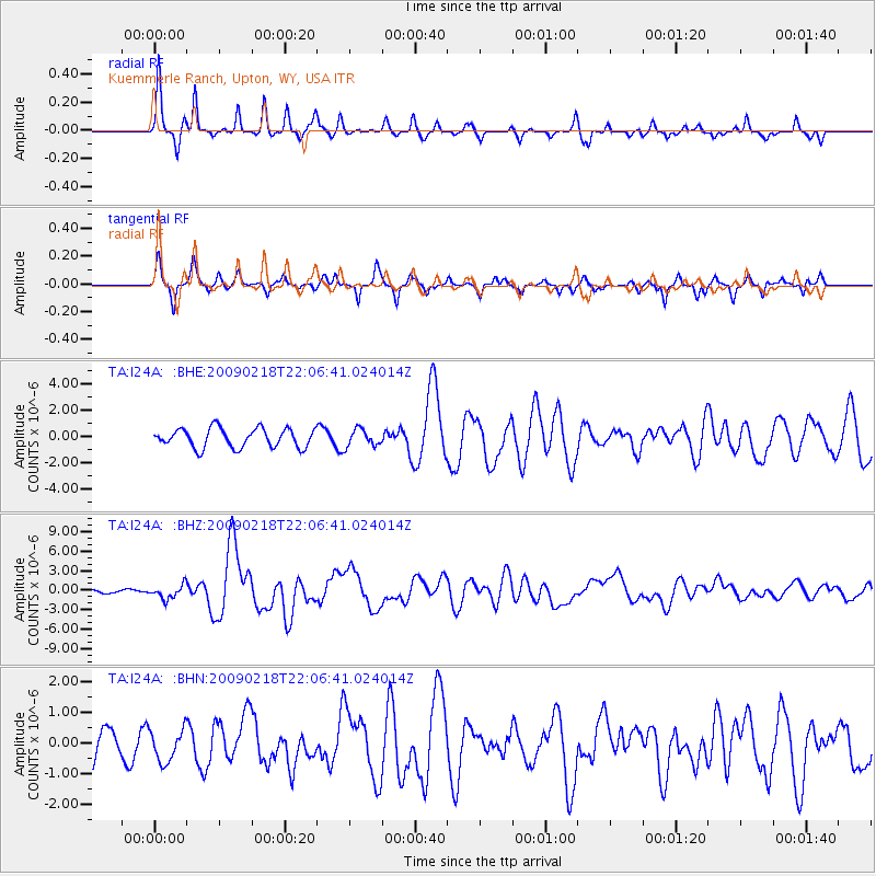
> Station I24A Kuemmerle Ranch, Upton, WY, USA > Earthquake Result Viewer
I24A Kuemmerle Ranch, Upton, WY, USA - Earthquake Result Viewer
| Earthquake location: |
Kermadec Islands Region |
| Earthquake latitude/longitude: |
-27.4/-176.3 |
| Earthquake time(UTC): |
2009/02/18 (049) 21:53:45 GMT |
| Earthquake Depth: |
25 km |
| Earthquake Magnitude: |
6.8 MB, 7.2 MS, 6.9 MW, 6.9 MW |
| Earthquake Catalog/Contributor: |
WHDF/NEIC |
|
| Network: |
TA USArray Transportable Network (new EarthScope stations) |
| Station: |
I24A Kuemmerle Ranch, Upton, WY, USA |
| Lat/Lon: |
43.86 N/104.63 W |
| Elevation: |
1338 m |
|
| Distance: |
96.6 deg |
| Az: |
43.736 deg |
| Baz: |
238.161 deg |
| Ray Param: |
0.040464688 |
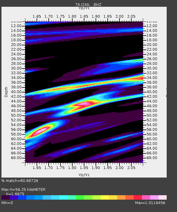
| Estimated Moho Depth: |
56.25 km |
| Estimated Crust Vp/Vs: |
1.67 |
| Assumed Crust Vp: |
6.159 km/s |
| Estimated Crust Vs: |
3.693 km/s |
| Estimated Crust Poisson's Ratio: |
0.22 |
|
| Radial Match: |
90.69726 % |
| Radial Bump: |
200 |
| Transverse Match: |
70.91171 % |
| Transverse Bump: |
282 |
| SOD ConfigId: |
2658 |
| Insert Time: |
2010-03-06 15:15:10.453 +0000 |
| GWidth: |
2.5 |
| Max Bumps: |
400 |
| Tol: |
0.001 |
|
Signal To Noise
| Channel | StoN | STA | LTA |
| TA:I24A: :BHZ:20090218T22:06:41.024014Z | 3.7303164 | 1.0560735E-6 | 2.831056E-7 |
| TA:I24A: :BHN:20090218T22:06:41.024014Z | 0.55756 | 5.207277E-7 | 9.3394016E-7 |
| TA:I24A: :BHE:20090218T22:06:41.024014Z | 0.89589924 | 6.4472096E-7 | 7.196355E-7 |
| Arrivals |
| Ps | 6.2 SECOND |
| PpPs | 24 SECOND |
| PsPs/PpSs | 30 SECOND |


