You are here: Home > Network List > TA - USArray Transportable Network (new EarthScope stations) Stations List
> Station H31M Peel River, Yukon, CAN > Earthquake Result Viewer
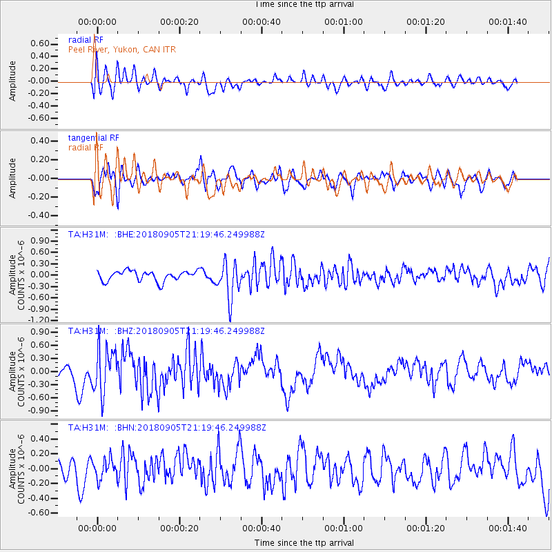
H31M Peel River, Yukon, CAN - Earthquake Result Viewer
*The percent match for this event was below the threshold and hence no stack was calculated.
| Earthquake location: |
Hokkaido, Japan Region |
| Earthquake latitude/longitude: |
42.7/142.0 |
| Earthquake time(UTC): |
2018/09/05 (248) 21:11:29 GMT |
| Earthquake Depth: |
36 km |
| Earthquake Magnitude: |
5.4 Mww |
| Earthquake Catalog/Contributor: |
NEIC PDE/us |
|
| Network: |
TA USArray Transportable Network (new EarthScope stations) |
| Station: |
H31M Peel River, Yukon, CAN |
| Lat/Lon: |
65.81 N/134.34 W |
| Elevation: |
642 m |
|
| Distance: |
49.6 deg |
| Az: |
32.563 deg |
| Baz: |
285.594 deg |
| Ray Param: |
$rayparam |
*The percent match for this event was below the threshold and hence was not used in the summary stack. |
|
| Radial Match: |
54.928257 % |
| Radial Bump: |
400 |
| Transverse Match: |
64.48149 % |
| Transverse Bump: |
400 |
| SOD ConfigId: |
13570011 |
| Insert Time: |
2019-05-01 03:01:54.188 +0000 |
| GWidth: |
2.5 |
| Max Bumps: |
400 |
| Tol: |
0.001 |
|
Signal To Noise
| Channel | StoN | STA | LTA |
| TA:H31M: :BHZ:20180905T21:19:46.249988Z | 3.0473318 | 5.239421E-7 | 1.719347E-7 |
| TA:H31M: :BHN:20180905T21:19:46.249988Z | 0.9086415 | 1.2943929E-7 | 1.4245363E-7 |
| TA:H31M: :BHE:20180905T21:19:46.249988Z | 3.5635257 | 4.8684603E-7 | 1.366192E-7 |
| Arrivals |
| Ps | |
| PpPs | |
| PsPs/PpSs | |


