You are here: Home > Network List > TA - USArray Transportable Network (new EarthScope stations) Stations List
> Station I30M Mount Dempster, Yukon, CAN > Earthquake Result Viewer
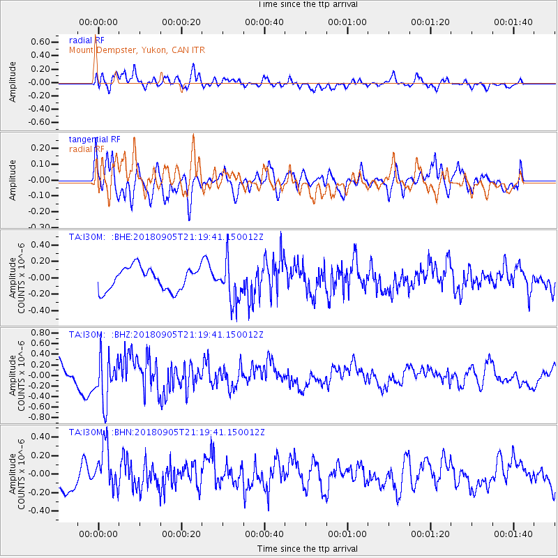
I30M Mount Dempster, Yukon, CAN - Earthquake Result Viewer
*The percent match for this event was below the threshold and hence no stack was calculated.
| Earthquake location: |
Hokkaido, Japan Region |
| Earthquake latitude/longitude: |
42.7/142.0 |
| Earthquake time(UTC): |
2018/09/05 (248) 21:11:29 GMT |
| Earthquake Depth: |
36 km |
| Earthquake Magnitude: |
5.4 Mww |
| Earthquake Catalog/Contributor: |
NEIC PDE/us |
|
| Network: |
TA USArray Transportable Network (new EarthScope stations) |
| Station: |
I30M Mount Dempster, Yukon, CAN |
| Lat/Lon: |
65.22 N/136.38 W |
| Elevation: |
1399 m |
|
| Distance: |
48.9 deg |
| Az: |
33.6 deg |
| Baz: |
284.422 deg |
| Ray Param: |
$rayparam |
*The percent match for this event was below the threshold and hence was not used in the summary stack. |
|
| Radial Match: |
73.7131 % |
| Radial Bump: |
400 |
| Transverse Match: |
57.91911 % |
| Transverse Bump: |
400 |
| SOD ConfigId: |
13570011 |
| Insert Time: |
2019-05-01 03:01:56.077 +0000 |
| GWidth: |
2.5 |
| Max Bumps: |
400 |
| Tol: |
0.001 |
|
Signal To Noise
| Channel | StoN | STA | LTA |
| TA:I30M: :BHZ:20180905T21:19:41.150012Z | 2.5221267 | 4.353405E-7 | 1.726085E-7 |
| TA:I30M: :BHN:20180905T21:19:41.150012Z | 1.3771158 | 2.4235882E-7 | 1.7599014E-7 |
| TA:I30M: :BHE:20180905T21:19:41.150012Z | 1.8803614 | 2.6088665E-7 | 1.3874282E-7 |
| Arrivals |
| Ps | |
| PpPs | |
| PsPs/PpSs | |


