You are here: Home > Network List > TA - USArray Transportable Network (new EarthScope stations) Stations List
> Station I24A Kuemmerle Ranch, Upton, WY, USA > Earthquake Result Viewer
I24A Kuemmerle Ranch, Upton, WY, USA - Earthquake Result Viewer

| Earthquake location: |
Kuril Islands |
| Earthquake latitude/longitude: |
46.0/151.4 |
| Earthquake time(UTC): |
2009/04/18 (108) 19:17:58 GMT |
| Earthquake Depth: |
35 km |
| Earthquake Magnitude: |
6.3 MB, 6.3 MS, 6.6 MW, 6.4 MW |
| Earthquake Catalog/Contributor: |
WHDF/NEIC |
|
| Network: |
TA USArray Transportable Network (new EarthScope stations) |
| Station: |
I24A Kuemmerle Ranch, Upton, WY, USA |
| Lat/Lon: |
43.86 N/104.63 W |
| Elevation: |
1338 m |
|
| Distance: |
68.1 deg |
| Az: |
49.189 deg |
| Baz: |
313.184 deg |
| Ray Param: |
0.05649794 |
| Estimated Moho Depth: |
56.5 km |
| Estimated Crust Vp/Vs: |
1.64 |
| Assumed Crust Vp: |
6.159 km/s |
| Estimated Crust Vs: |
3.75 km/s |
| Estimated Crust Poisson's Ratio: |
0.21 |
|
| Radial Match: |
92.452545 % |
| Radial Bump: |
344 |
| Transverse Match: |
74.42982 % |
| Transverse Bump: |
400 |
| SOD ConfigId: |
2658 |
| Insert Time: |
2010-03-06 15:15:14.026 +0000 |
| GWidth: |
2.5 |
| Max Bumps: |
400 |
| Tol: |
0.001 |
|
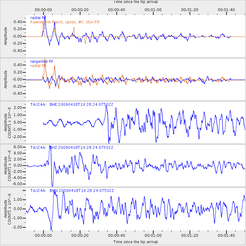
Signal To Noise
| Channel | StoN | STA | LTA |
| TA:I24A: :BHZ:20090418T19:28:24.07502Z | 30.394922 | 3.168426E-6 | 1.04241956E-7 |
| TA:I24A: :BHN:20090418T19:28:24.07502Z | 4.474502 | 9.2235734E-7 | 2.0613629E-7 |
| TA:I24A: :BHE:20090418T19:28:24.07502Z | 3.8709643 | 9.243076E-7 | 2.3877968E-7 |
| Arrivals |
| Ps | 6.1 SECOND |
| PpPs | 23 SECOND |
| PsPs/PpSs | 29 SECOND |


