You are here: Home > Network List > TA - USArray Transportable Network (new EarthScope stations) Stations List
> Station K15K Wolf Creek Mountain, AK, USA > Earthquake Result Viewer
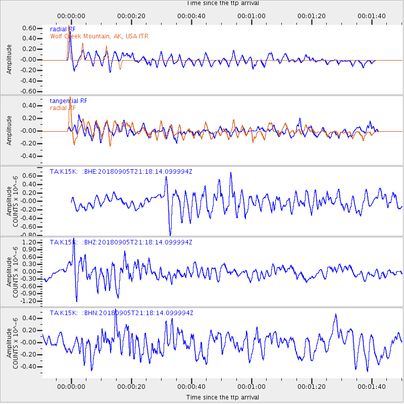
K15K Wolf Creek Mountain, AK, USA - Earthquake Result Viewer
*The percent match for this event was below the threshold and hence no stack was calculated.
| Earthquake location: |
Hokkaido, Japan Region |
| Earthquake latitude/longitude: |
42.7/142.0 |
| Earthquake time(UTC): |
2018/09/05 (248) 21:11:29 GMT |
| Earthquake Depth: |
36 km |
| Earthquake Magnitude: |
5.4 Mww |
| Earthquake Catalog/Contributor: |
NEIC PDE/us |
|
| Network: |
TA USArray Transportable Network (new EarthScope stations) |
| Station: |
K15K Wolf Creek Mountain, AK, USA |
| Lat/Lon: |
62.29 N/161.53 W |
| Elevation: |
346 m |
|
| Distance: |
38.1 deg |
| Az: |
39.205 deg |
| Baz: |
265.898 deg |
| Ray Param: |
$rayparam |
*The percent match for this event was below the threshold and hence was not used in the summary stack. |
|
| Radial Match: |
78.33684 % |
| Radial Bump: |
400 |
| Transverse Match: |
73.59864 % |
| Transverse Bump: |
400 |
| SOD ConfigId: |
13570011 |
| Insert Time: |
2019-05-01 03:02:02.300 +0000 |
| GWidth: |
2.5 |
| Max Bumps: |
400 |
| Tol: |
0.001 |
|
Signal To Noise
| Channel | StoN | STA | LTA |
| TA:K15K: :BHZ:20180905T21:18:14.099994Z | 2.5166035 | 6.585193E-7 | 2.6166987E-7 |
| TA:K15K: :BHN:20180905T21:18:14.099994Z | 1.0846133 | 1.4958212E-7 | 1.3791286E-7 |
| TA:K15K: :BHE:20180905T21:18:14.099994Z | 3.3296204 | 3.5719762E-7 | 1.0727879E-7 |
| Arrivals |
| Ps | |
| PpPs | |
| PsPs/PpSs | |


