You are here: Home > Network List > TA - USArray Transportable Network (new EarthScope stations) Stations List
> Station L15K Ungalak Mountain, AK, USA > Earthquake Result Viewer
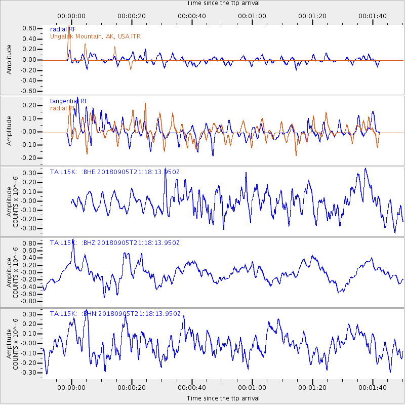
L15K Ungalak Mountain, AK, USA - Earthquake Result Viewer
*The percent match for this event was below the threshold and hence no stack was calculated.
| Earthquake location: |
Hokkaido, Japan Region |
| Earthquake latitude/longitude: |
42.7/142.0 |
| Earthquake time(UTC): |
2018/09/05 (248) 21:11:29 GMT |
| Earthquake Depth: |
36 km |
| Earthquake Magnitude: |
5.4 Mww |
| Earthquake Catalog/Contributor: |
NEIC PDE/us |
|
| Network: |
TA USArray Transportable Network (new EarthScope stations) |
| Station: |
L15K Ungalak Mountain, AK, USA |
| Lat/Lon: |
61.68 N/161.49 W |
| Elevation: |
219 m |
|
| Distance: |
38.1 deg |
| Az: |
40.208 deg |
| Baz: |
266.726 deg |
| Ray Param: |
$rayparam |
*The percent match for this event was below the threshold and hence was not used in the summary stack. |
|
| Radial Match: |
68.7177 % |
| Radial Bump: |
400 |
| Transverse Match: |
65.70026 % |
| Transverse Bump: |
400 |
| SOD ConfigId: |
13570011 |
| Insert Time: |
2019-05-01 03:02:07.364 +0000 |
| GWidth: |
2.5 |
| Max Bumps: |
400 |
| Tol: |
0.001 |
|
Signal To Noise
| Channel | StoN | STA | LTA |
| TA:L15K: :BHZ:20180905T21:18:13.950Z | 1.9494914 | 4.3218213E-7 | 2.2168969E-7 |
| TA:L15K: :BHN:20180905T21:18:13.950Z | 1.6420126 | 1.7891801E-7 | 1.0896264E-7 |
| TA:L15K: :BHE:20180905T21:18:13.950Z | 2.1856906 | 1.564151E-7 | 7.1563235E-8 |
| Arrivals |
| Ps | |
| PpPs | |
| PsPs/PpSs | |


