You are here: Home > Network List > TA - USArray Transportable Network (new EarthScope stations) Stations List
> Station I24A Kuemmerle Ranch, Upton, WY, USA > Earthquake Result Viewer
I24A Kuemmerle Ranch, Upton, WY, USA - Earthquake Result Viewer
| Earthquake location: |
Guatemala |
| Earthquake latitude/longitude: |
14.6/-91.2 |
| Earthquake time(UTC): |
2009/05/03 (123) 16:21:47 GMT |
| Earthquake Depth: |
124 km |
| Earthquake Magnitude: |
5.6 MB, 6.2 MW, 6.2 MW |
| Earthquake Catalog/Contributor: |
WHDF/NEIC |
|
| Network: |
TA USArray Transportable Network (new EarthScope stations) |
| Station: |
I24A Kuemmerle Ranch, Upton, WY, USA |
| Lat/Lon: |
43.86 N/104.63 W |
| Elevation: |
1338 m |
|
| Distance: |
31.4 deg |
| Az: |
341.135 deg |
| Baz: |
154.355 deg |
| Ray Param: |
0.07876186 |
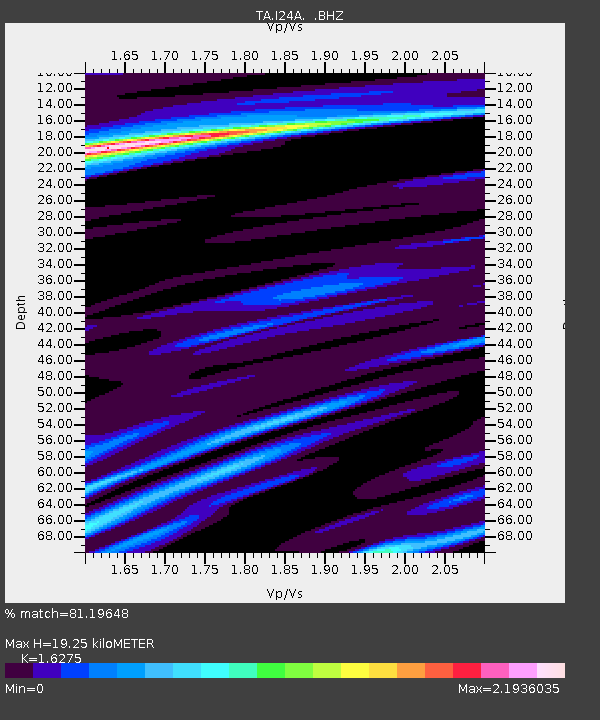
| Estimated Moho Depth: |
19.25 km |
| Estimated Crust Vp/Vs: |
1.63 |
| Assumed Crust Vp: |
6.159 km/s |
| Estimated Crust Vs: |
3.784 km/s |
| Estimated Crust Poisson's Ratio: |
0.20 |
|
| Radial Match: |
81.19648 % |
| Radial Bump: |
356 |
| Transverse Match: |
55.839626 % |
| Transverse Bump: |
361 |
| SOD ConfigId: |
2658 |
| Insert Time: |
2010-03-06 15:15:24.645 +0000 |
| GWidth: |
2.5 |
| Max Bumps: |
400 |
| Tol: |
0.001 |
|
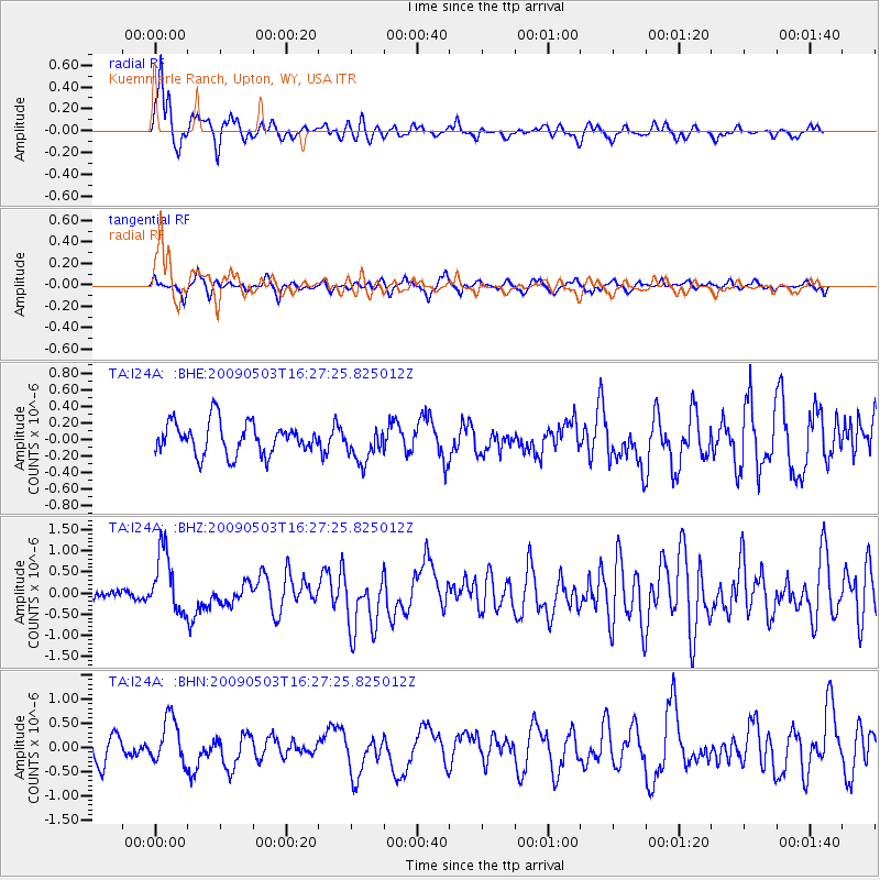
Signal To Noise
| Channel | StoN | STA | LTA |
| TA:I24A: :BHZ:20090503T16:27:25.825012Z | 5.396079 | 7.239775E-7 | 1.3416732E-7 |
| TA:I24A: :BHN:20090503T16:27:25.825012Z | 1.8104278 | 4.6842177E-7 | 2.587354E-7 |
| TA:I24A: :BHE:20090503T16:27:25.825012Z | 1.1160097 | 2.161515E-7 | 1.9368247E-7 |
| Arrivals |
| Ps | 2.1 SECOND |
| PpPs | 7.6 SECOND |
| PsPs/PpSs | 9.7 SECOND |


