You are here: Home > Network List > UW - Pacific Northwest Regional Seismic Network Stations List
> Station LEBA Lebam, WA, USA > Earthquake Result Viewer
LEBA Lebam, WA, USA - Earthquake Result Viewer
*The percent match for this event was below the threshold and hence no stack was calculated.
| Earthquake location: |
Hokkaido, Japan Region |
| Earthquake latitude/longitude: |
42.7/142.0 |
| Earthquake time(UTC): |
2018/09/05 (248) 21:11:29 GMT |
| Earthquake Depth: |
36 km |
| Earthquake Magnitude: |
5.4 Mww |
| Earthquake Catalog/Contributor: |
NEIC PDE/us |
|
| Network: |
UW Pacific Northwest Regional Seismic Network |
| Station: |
LEBA Lebam, WA, USA |
| Lat/Lon: |
46.55 N/123.56 W |
| Elevation: |
73 m |
|
| Distance: |
63.3 deg |
| Az: |
50.357 deg |
| Baz: |
304.63 deg |
| Ray Param: |
$rayparam |
*The percent match for this event was below the threshold and hence was not used in the summary stack. |
|
| Radial Match: |
51.202606 % |
| Radial Bump: |
400 |
| Transverse Match: |
57.70397 % |
| Transverse Bump: |
400 |
| SOD ConfigId: |
13570011 |
| Insert Time: |
2019-05-01 03:03:34.654 +0000 |
| GWidth: |
2.5 |
| Max Bumps: |
400 |
| Tol: |
0.001 |
|
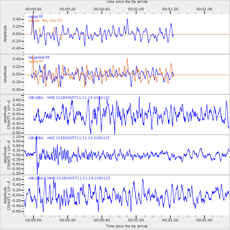
Signal To Noise
| Channel | StoN | STA | LTA |
| UW:LEBA: :HHZ:20180905T21:21:24.038013Z | 3.254477 | 5.054027E-7 | 1.552946E-7 |
| UW:LEBA: :HHN:20180905T21:21:24.038013Z | 2.1704946 | 2.9108426E-7 | 1.3410964E-7 |
| UW:LEBA: :HHE:20180905T21:21:24.038013Z | 1.8996103 | 4.040828E-7 | 2.1271879E-7 |
| Arrivals |
| Ps | |
| PpPs | |
| PsPs/PpSs | |


