You are here: Home > Network List > TA - USArray Transportable Network (new EarthScope stations) Stations List
> Station I24A Kuemmerle Ranch, Upton, WY, USA > Earthquake Result Viewer
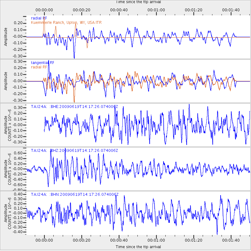
I24A Kuemmerle Ranch, Upton, WY, USA - Earthquake Result Viewer
*The percent match for this event was below the threshold and hence no stack was calculated.
| Earthquake location: |
Eastern Mediterranean Sea |
| Earthquake latitude/longitude: |
35.4/28.5 |
| Earthquake time(UTC): |
2009/06/19 (170) 14:04:59 GMT |
| Earthquake Depth: |
28 km |
| Earthquake Magnitude: |
5.6 MB, 5.6 MS, 5.8 MW, 5.8 MW |
| Earthquake Catalog/Contributor: |
WHDF/NEIC |
|
| Network: |
TA USArray Transportable Network (new EarthScope stations) |
| Station: |
I24A Kuemmerle Ranch, Upton, WY, USA |
| Lat/Lon: |
43.86 N/104.63 W |
| Elevation: |
1338 m |
|
| Distance: |
90.3 deg |
| Az: |
328.105 deg |
| Baz: |
36.658 deg |
| Ray Param: |
$rayparam |
*The percent match for this event was below the threshold and hence was not used in the summary stack. |
|
| Radial Match: |
59.977135 % |
| Radial Bump: |
400 |
| Transverse Match: |
66.87701 % |
| Transverse Bump: |
400 |
| SOD ConfigId: |
2648 |
| Insert Time: |
2010-03-06 15:16:34.042 +0000 |
| GWidth: |
2.5 |
| Max Bumps: |
400 |
| Tol: |
0.001 |
|
Signal To Noise
| Channel | StoN | STA | LTA |
| TA:I24A: :BHZ:20090619T14:17:26.074006Z | 4.1769195 | 3.041839E-7 | 7.282493E-8 |
| TA:I24A: :BHN:20090619T14:17:26.074006Z | 1.031802 | 9.654797E-8 | 9.357218E-8 |
| TA:I24A: :BHE:20090619T14:17:26.074006Z | 1.1612418 | 9.7857594E-8 | 8.4269786E-8 |
| Arrivals |
| Ps | |
| PpPs | |
| PsPs/PpSs | |


