You are here: Home > Network List > TA - USArray Transportable Network (new EarthScope stations) Stations List
> Station I24A Kuemmerle Ranch, Upton, WY, USA > Earthquake Result Viewer
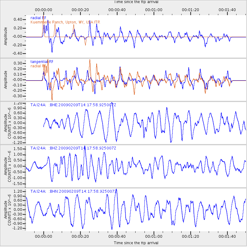
I24A Kuemmerle Ranch, Upton, WY, USA - Earthquake Result Viewer
*The percent match for this event was below the threshold and hence no stack was calculated.
| Earthquake location: |
Near Coast Of Northern Peru |
| Earthquake latitude/longitude: |
-6.6/-81.2 |
| Earthquake time(UTC): |
2009/02/09 (040) 14:09:02 GMT |
| Earthquake Depth: |
15 km |
| Earthquake Magnitude: |
5.5 MB, 5.5 MS, 6.0 MW, 5.9 MW |
| Earthquake Catalog/Contributor: |
WHDF/NEIC |
|
| Network: |
TA USArray Transportable Network (new EarthScope stations) |
| Station: |
I24A Kuemmerle Ranch, Upton, WY, USA |
| Lat/Lon: |
43.86 N/104.63 W |
| Elevation: |
1338 m |
|
| Distance: |
54.5 deg |
| Az: |
339.269 deg |
| Baz: |
150.91 deg |
| Ray Param: |
$rayparam |
*The percent match for this event was below the threshold and hence was not used in the summary stack. |
|
| Radial Match: |
50.299515 % |
| Radial Bump: |
358 |
| Transverse Match: |
61.034496 % |
| Transverse Bump: |
340 |
| SOD ConfigId: |
2658 |
| Insert Time: |
2010-03-06 15:16:54.793 +0000 |
| GWidth: |
2.5 |
| Max Bumps: |
400 |
| Tol: |
0.001 |
|
Signal To Noise
| Channel | StoN | STA | LTA |
| TA:I24A: :BHZ:20090209T14:17:58.925007Z | 2.4193532 | 5.9852044E-7 | 2.473886E-7 |
| TA:I24A: :BHN:20090209T14:17:58.925007Z | 0.61955357 | 2.549141E-7 | 4.114481E-7 |
| TA:I24A: :BHE:20090209T14:17:58.925007Z | 1.8104486 | 6.8117646E-7 | 3.7624736E-7 |
| Arrivals |
| Ps | |
| PpPs | |
| PsPs/PpSs | |


