You are here: Home > Network List > TA - USArray Transportable Network (new EarthScope stations) Stations List
> Station J24A Dixon Ranch, Lance Creek, WY, USA > Earthquake Result Viewer
J24A Dixon Ranch, Lance Creek, WY, USA - Earthquake Result Viewer
| Earthquake location: |
Southeast Of Honshu, Japan |
| Earthquake latitude/longitude: |
32.8/140.4 |
| Earthquake time(UTC): |
2009/08/12 (224) 22:48:51 GMT |
| Earthquake Depth: |
53 km |
| Earthquake Magnitude: |
6.2 MB, 6.6 MW, 6.6 MW |
| Earthquake Catalog/Contributor: |
WHDF/NEIC |
|
| Network: |
TA USArray Transportable Network (new EarthScope stations) |
| Station: |
J24A Dixon Ranch, Lance Creek, WY, USA |
| Lat/Lon: |
43.33 N/104.66 W |
| Elevation: |
1315 m |
|
| Distance: |
83.7 deg |
| Az: |
41.733 deg |
| Baz: |
309.815 deg |
| Ray Param: |
0.045906924 |
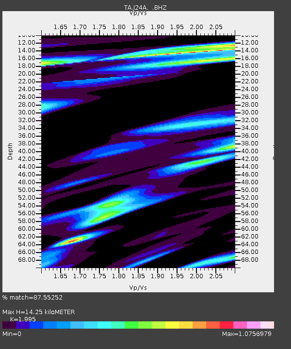
| Estimated Moho Depth: |
14.25 km |
| Estimated Crust Vp/Vs: |
2.00 |
| Assumed Crust Vp: |
6.159 km/s |
| Estimated Crust Vs: |
3.087 km/s |
| Estimated Crust Poisson's Ratio: |
0.33 |
|
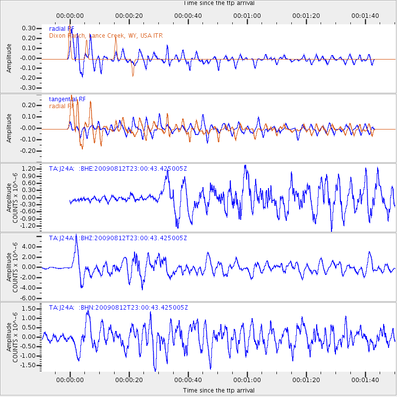
| Radial Match: |
87.55252 % |
| Radial Bump: |
400 |
| Transverse Match: |
76.16976 % |
| Transverse Bump: |
400 |
| SOD ConfigId: |
2622 |
| Insert Time: |
2010-03-06 15:17:09.051 +0000 |
| GWidth: |
2.5 |
| Max Bumps: |
400 |
| Tol: |
0.001 |
|
Signal To Noise
| Channel | StoN | STA | LTA |
| TA:J24A: :BHZ:20090812T23:00:43.425005Z | 20.561735 | 2.7378687E-6 | 1.3315359E-7 |
| TA:J24A: :BHN:20090812T23:00:43.425005Z | 3.9297423 | 5.4890626E-7 | 1.3967997E-7 |
| TA:J24A: :BHE:20090812T23:00:43.425005Z | 6.2198715 | 5.238665E-7 | 8.422465E-8 |
| Arrivals |
| Ps | 2.4 SECOND |
| PpPs | 6.8 SECOND |
| PsPs/PpSs | 9.1 SECOND |


