You are here: Home > Network List > TA - USArray Transportable Network (new EarthScope stations) Stations List
> Station G31M Satah River, YT, CAN > Earthquake Result Viewer
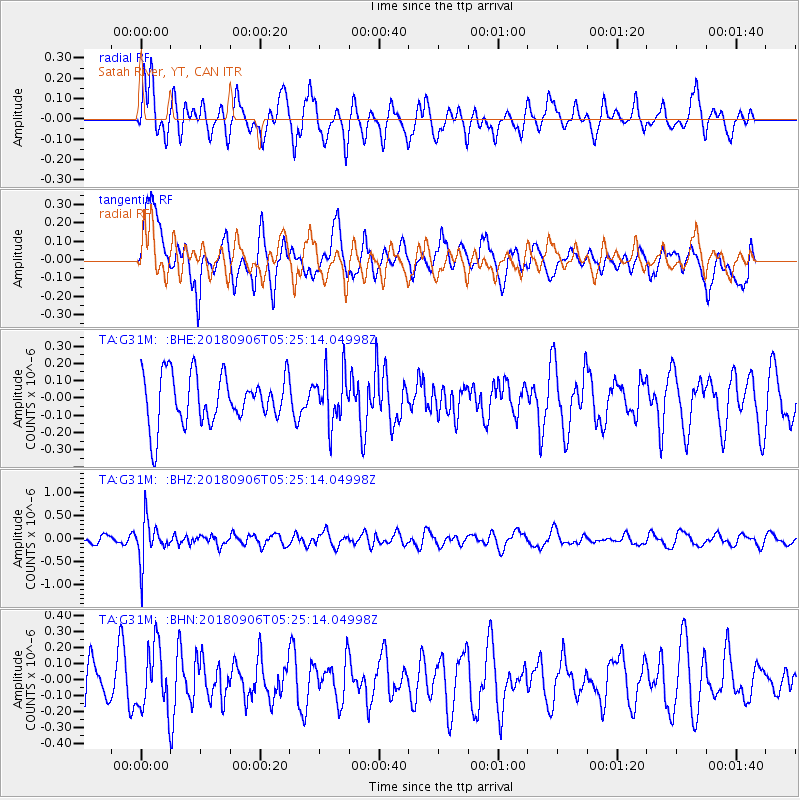
G31M Satah River, YT, CAN - Earthquake Result Viewer
*The percent match for this event was below the threshold and hence no stack was calculated.
| Earthquake location: |
Fiji Islands Region |
| Earthquake latitude/longitude: |
-18.0/-178.5 |
| Earthquake time(UTC): |
2018/09/06 (249) 05:13:39 GMT |
| Earthquake Depth: |
531 km |
| Earthquake Magnitude: |
5.5 Mww |
| Earthquake Catalog/Contributor: |
NEIC PDE/us |
|
| Network: |
TA USArray Transportable Network (new EarthScope stations) |
| Station: |
G31M Satah River, YT, CAN |
| Lat/Lon: |
66.92 N/134.27 W |
| Elevation: |
61 m |
|
| Distance: |
90.8 deg |
| Az: |
15.97 deg |
| Baz: |
221.629 deg |
| Ray Param: |
$rayparam |
*The percent match for this event was below the threshold and hence was not used in the summary stack. |
|
| Radial Match: |
52.138504 % |
| Radial Bump: |
366 |
| Transverse Match: |
53.491066 % |
| Transverse Bump: |
400 |
| SOD ConfigId: |
13570011 |
| Insert Time: |
2019-05-01 03:11:41.413 +0000 |
| GWidth: |
2.5 |
| Max Bumps: |
400 |
| Tol: |
0.001 |
|
Signal To Noise
| Channel | StoN | STA | LTA |
| TA:G31M: :BHZ:20180906T05:25:14.04998Z | 5.133866 | 4.5523097E-7 | 8.867216E-8 |
| TA:G31M: :BHN:20180906T05:25:14.04998Z | 1.5163215 | 2.0117591E-7 | 1.3267365E-7 |
| TA:G31M: :BHE:20180906T05:25:14.04998Z | 1.0275013 | 1.4667887E-7 | 1.4275298E-7 |
| Arrivals |
| Ps | |
| PpPs | |
| PsPs/PpSs | |


