You are here: Home > Network List > TA - USArray Transportable Network (new EarthScope stations) Stations List
> Station J24A Dixon Ranch, Lance Creek, WY, USA > Earthquake Result Viewer
J24A Dixon Ranch, Lance Creek, WY, USA - Earthquake Result Viewer
| Earthquake location: |
Northern Mid-Atlantic Ridge |
| Earthquake latitude/longitude: |
23.9/-46.1 |
| Earthquake time(UTC): |
2009/06/06 (157) 20:33:28 GMT |
| Earthquake Depth: |
14 km |
| Earthquake Magnitude: |
6.0 MB, 5.7 MS, 6.0 MW, 6.0 MW |
| Earthquake Catalog/Contributor: |
WHDF/NEIC |
|
| Network: |
TA USArray Transportable Network (new EarthScope stations) |
| Station: |
J24A Dixon Ranch, Lance Creek, WY, USA |
| Lat/Lon: |
43.33 N/104.66 W |
| Elevation: |
1315 m |
|
| Distance: |
51.4 deg |
| Az: |
307.218 deg |
| Baz: |
92.419 deg |
| Ray Param: |
0.067414746 |
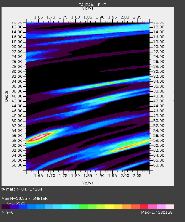
| Estimated Moho Depth: |
56.25 km |
| Estimated Crust Vp/Vs: |
1.65 |
| Assumed Crust Vp: |
6.159 km/s |
| Estimated Crust Vs: |
3.727 km/s |
| Estimated Crust Poisson's Ratio: |
0.21 |
|
| Radial Match: |
84.714264 % |
| Radial Bump: |
400 |
| Transverse Match: |
79.08404 % |
| Transverse Bump: |
400 |
| SOD ConfigId: |
2648 |
| Insert Time: |
2010-03-06 15:17:22.500 +0000 |
| GWidth: |
2.5 |
| Max Bumps: |
400 |
| Tol: |
0.001 |
|
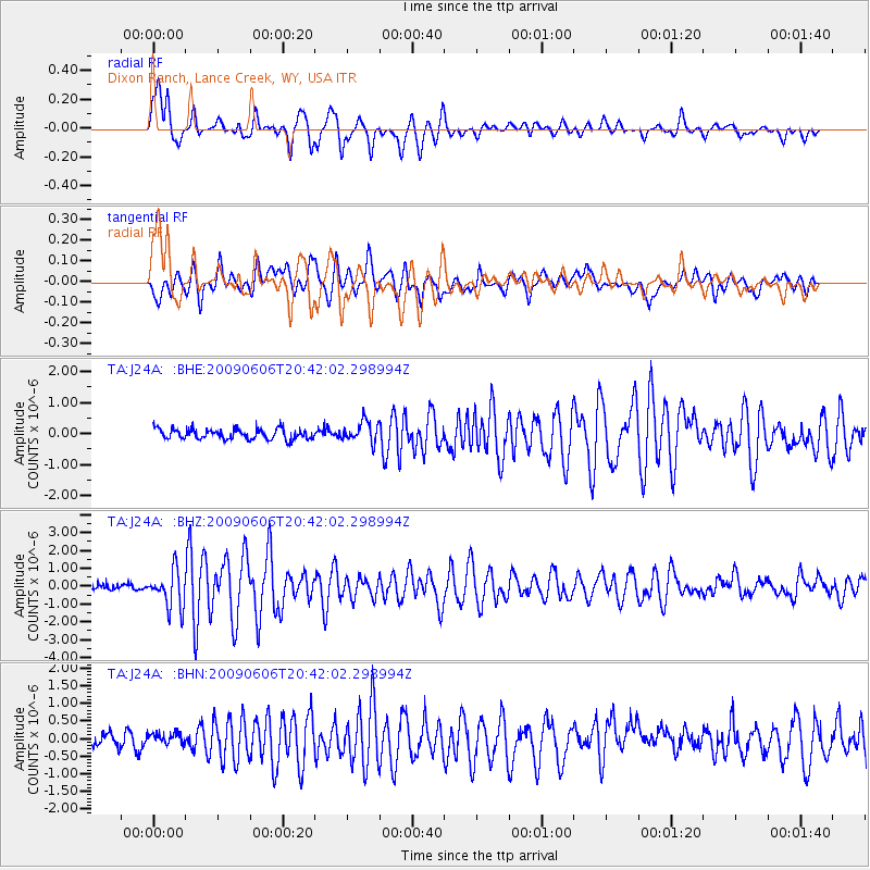
Signal To Noise
| Channel | StoN | STA | LTA |
| TA:J24A: :BHZ:20090606T20:42:02.298994Z | 7.7739825 | 1.0421214E-6 | 1.3405246E-7 |
| TA:J24A: :BHN:20090606T20:42:02.298994Z | 0.88045233 | 1.6153245E-7 | 1.834653E-7 |
| TA:J24A: :BHE:20090606T20:42:02.298994Z | 2.0166066 | 3.282601E-7 | 1.6277846E-7 |
| Arrivals |
| Ps | 6.3 SECOND |
| PpPs | 23 SECOND |
| PsPs/PpSs | 29 SECOND |


