You are here: Home > Network List > TA - USArray Transportable Network (new EarthScope stations) Stations List
> Station L15K Ungalak Mountain, AK, USA > Earthquake Result Viewer
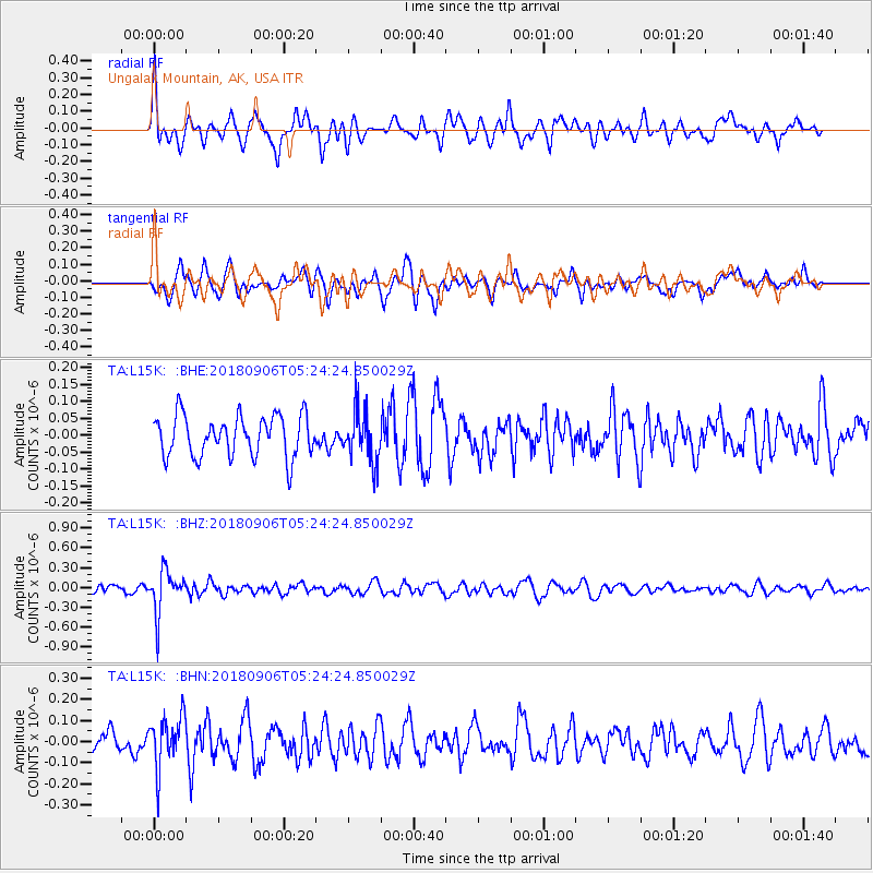
L15K Ungalak Mountain, AK, USA - Earthquake Result Viewer
*The percent match for this event was below the threshold and hence no stack was calculated.
| Earthquake location: |
Fiji Islands Region |
| Earthquake latitude/longitude: |
-18.0/-178.5 |
| Earthquake time(UTC): |
2018/09/06 (249) 05:13:39 GMT |
| Earthquake Depth: |
531 km |
| Earthquake Magnitude: |
5.5 Mww |
| Earthquake Catalog/Contributor: |
NEIC PDE/us |
|
| Network: |
TA USArray Transportable Network (new EarthScope stations) |
| Station: |
L15K Ungalak Mountain, AK, USA |
| Lat/Lon: |
61.68 N/161.49 W |
| Elevation: |
219 m |
|
| Distance: |
80.5 deg |
| Az: |
8.146 deg |
| Baz: |
196.427 deg |
| Ray Param: |
$rayparam |
*The percent match for this event was below the threshold and hence was not used in the summary stack. |
|
| Radial Match: |
61.839344 % |
| Radial Bump: |
400 |
| Transverse Match: |
62.75988 % |
| Transverse Bump: |
398 |
| SOD ConfigId: |
13570011 |
| Insert Time: |
2019-05-01 03:12:10.856 +0000 |
| GWidth: |
2.5 |
| Max Bumps: |
400 |
| Tol: |
0.001 |
|
Signal To Noise
| Channel | StoN | STA | LTA |
| TA:L15K: :BHZ:20180906T05:24:24.850029Z | 5.4550877 | 3.2396943E-7 | 5.9388494E-8 |
| TA:L15K: :BHN:20180906T05:24:24.850029Z | 2.578048 | 1.218976E-7 | 4.7282906E-8 |
| TA:L15K: :BHE:20180906T05:24:24.850029Z | 1.2817675 | 7.7456434E-8 | 6.042939E-8 |
| Arrivals |
| Ps | |
| PpPs | |
| PsPs/PpSs | |


