You are here: Home > Network List > TA - USArray Transportable Network (new EarthScope stations) Stations List
> Station J24A Dixon Ranch, Lance Creek, WY, USA > Earthquake Result Viewer
J24A Dixon Ranch, Lance Creek, WY, USA - Earthquake Result Viewer
| Earthquake location: |
Kuril Islands |
| Earthquake latitude/longitude: |
46.0/151.4 |
| Earthquake time(UTC): |
2009/04/18 (108) 19:17:58 GMT |
| Earthquake Depth: |
35 km |
| Earthquake Magnitude: |
6.3 MB, 6.3 MS, 6.6 MW, 6.4 MW |
| Earthquake Catalog/Contributor: |
WHDF/NEIC |
|
| Network: |
TA USArray Transportable Network (new EarthScope stations) |
| Station: |
J24A Dixon Ranch, Lance Creek, WY, USA |
| Lat/Lon: |
43.33 N/104.66 W |
| Elevation: |
1315 m |
|
| Distance: |
68.4 deg |
| Az: |
49.623 deg |
| Baz: |
313.32 deg |
| Ray Param: |
0.05627329 |
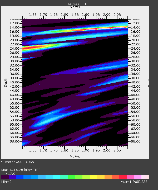
| Estimated Moho Depth: |
14.25 km |
| Estimated Crust Vp/Vs: |
2.00 |
| Assumed Crust Vp: |
6.159 km/s |
| Estimated Crust Vs: |
3.079 km/s |
| Estimated Crust Poisson's Ratio: |
0.33 |
|
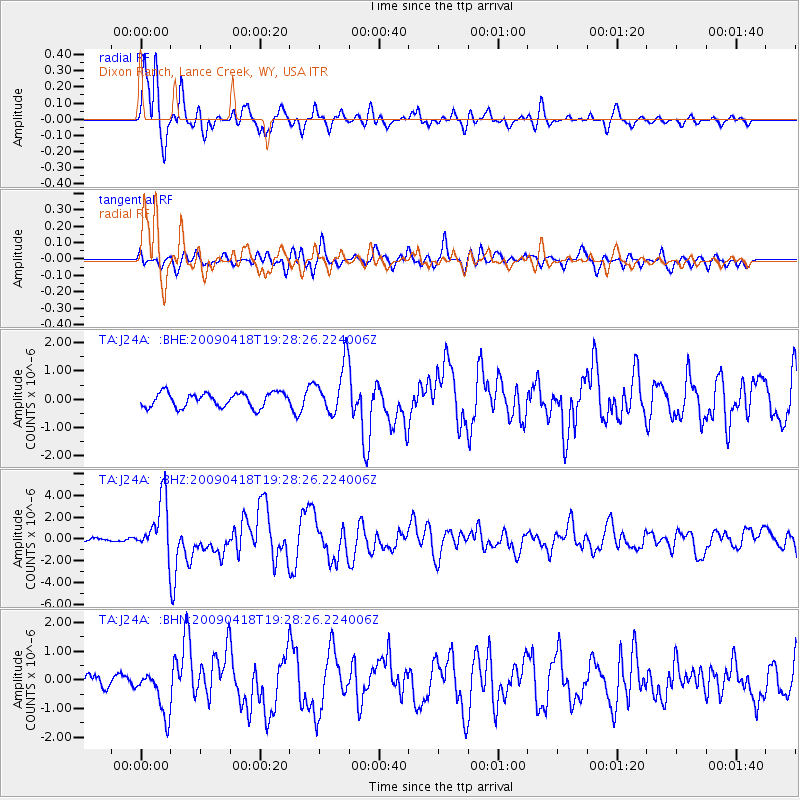
| Radial Match: |
90.04965 % |
| Radial Bump: |
400 |
| Transverse Match: |
70.27263 % |
| Transverse Bump: |
400 |
| SOD ConfigId: |
2760 |
| Insert Time: |
2010-03-06 15:17:38.713 +0000 |
| GWidth: |
2.5 |
| Max Bumps: |
400 |
| Tol: |
0.001 |
|
Signal To Noise
| Channel | StoN | STA | LTA |
| TA:J24A: :BHZ:20090418T19:28:26.224006Z | 13.910852 | 2.5811175E-6 | 1.8554705E-7 |
| TA:J24A: :BHN:20090418T19:28:26.224006Z | 3.6166341 | 7.7506786E-7 | 2.143064E-7 |
| TA:J24A: :BHE:20090418T19:28:26.224006Z | 3.460378 | 8.733038E-7 | 2.523724E-7 |
| Arrivals |
| Ps | 2.4 SECOND |
| PpPs | 6.7 SECOND |
| PsPs/PpSs | 9.1 SECOND |


