You are here: Home > Network List > IU - Global Seismograph Network (GSN - IRIS/USGS) Stations List
> Station JOHN Johnston Island, USA > Earthquake Result Viewer
JOHN Johnston Island, USA - Earthquake Result Viewer
| Earthquake location: |
Kermadec Islands Region |
| Earthquake latitude/longitude: |
-28.0/-176.4 |
| Earthquake time(UTC): |
2016/07/13 (195) 12:11:13 GMT |
| Earthquake Depth: |
12 km |
| Earthquake Magnitude: |
6.3 MWB |
| Earthquake Catalog/Contributor: |
NEIC PDE/NEIC COMCAT |
|
| Network: |
IU Global Seismograph Network (GSN - IRIS/USGS) |
| Station: |
JOHN Johnston Island, USA |
| Lat/Lon: |
16.73 N/169.53 W |
| Elevation: |
2.0 m |
|
| Distance: |
45.0 deg |
| Az: |
9.311 deg |
| Baz: |
188.585 deg |
| Ray Param: |
0.071565 |
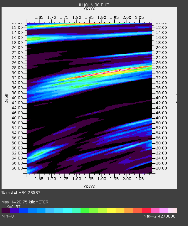
| Estimated Moho Depth: |
28.75 km |
| Estimated Crust Vp/Vs: |
1.97 |
| Assumed Crust Vp: |
4.24 km/s |
| Estimated Crust Vs: |
2.152 km/s |
| Estimated Crust Poisson's Ratio: |
0.33 |
|
| Radial Match: |
80.23537 % |
| Radial Bump: |
400 |
| Transverse Match: |
51.161407 % |
| Transverse Bump: |
400 |
| SOD ConfigId: |
1634031 |
| Insert Time: |
2016-07-27 12:12:48.847 +0000 |
| GWidth: |
2.5 |
| Max Bumps: |
400 |
| Tol: |
0.001 |
|

Signal To Noise
| Channel | StoN | STA | LTA |
| IU:JOHN:00:BHZ:20160713T12:18:57.268988Z | 3.5691862 | 3.9075703E-6 | 1.0948071E-6 |
| IU:JOHN:00:BH1:20160713T12:18:57.268988Z | 1.7233171 | 4.3004825E-6 | 2.4954677E-6 |
| IU:JOHN:00:BH2:20160713T12:18:57.268988Z | 0.81913793 | 3.1749087E-6 | 3.8759144E-6 |
| Arrivals |
| Ps | 6.7 SECOND |
| PpPs | 20 SECOND |
| PsPs/PpSs | 26 SECOND |


