You are here: Home > Network List > AV - Alaska Volcano Observatory Stations List
> Station SPCR Ckakachatna River, Mount Spurr, Alaska > Earthquake Result Viewer
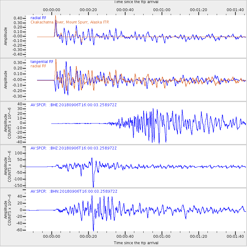
SPCR Ckakachatna River, Mount Spurr, Alaska - Earthquake Result Viewer
*The percent match for this event was below the threshold and hence no stack was calculated.
| Earthquake location: |
Fiji Islands |
| Earthquake latitude/longitude: |
-18.4/179.5 |
| Earthquake time(UTC): |
2018/09/06 (249) 15:49:17 GMT |
| Earthquake Depth: |
669 km |
| Earthquake Magnitude: |
8.1 Mi |
| Earthquake Catalog/Contributor: |
NEIC PDE/at |
|
| Network: |
AV Alaska Volcano Observatory |
| Station: |
SPCR Ckakachatna River, Mount Spurr, Alaska |
| Lat/Lon: |
61.20 N/152.21 W |
| Elevation: |
984 m |
|
| Distance: |
82.5 deg |
| Az: |
13.384 deg |
| Baz: |
206.994 deg |
| Ray Param: |
$rayparam |
*The percent match for this event was below the threshold and hence was not used in the summary stack. |
|
| Radial Match: |
96.02444 % |
| Radial Bump: |
400 |
| Transverse Match: |
95.41698 % |
| Transverse Bump: |
400 |
| SOD ConfigId: |
13570011 |
| Insert Time: |
2019-05-01 03:18:23.119 +0000 |
| GWidth: |
2.5 |
| Max Bumps: |
400 |
| Tol: |
0.001 |
|
Signal To Noise
| Channel | StoN | STA | LTA |
| AV:SPCR: :BHZ:20180906T16:00:03.258972Z | 32.084057 | 6.4312544E-6 | 2.0045016E-7 |
| AV:SPCR: :BHN:20180906T16:00:03.258972Z | 9.513855 | 1.8500905E-6 | 1.9446274E-7 |
| AV:SPCR: :BHE:20180906T16:00:03.258972Z | 7.2865624 | 7.02719E-7 | 9.6440395E-8 |
| Arrivals |
| Ps | |
| PpPs | |
| PsPs/PpSs | |


