You are here: Home > Network List > CI - Caltech Regional Seismic Network Stations List
> Station PDM Parker Dam, Lake Havasu City, AZ, USA > Earthquake Result Viewer
PDM Parker Dam, Lake Havasu City, AZ, USA - Earthquake Result Viewer
| Earthquake location: |
Southeast Of Honshu, Japan |
| Earthquake latitude/longitude: |
32.8/140.4 |
| Earthquake time(UTC): |
2009/08/12 (224) 22:48:51 GMT |
| Earthquake Depth: |
53 km |
| Earthquake Magnitude: |
6.2 MB, 6.6 MW, 6.6 MW |
| Earthquake Catalog/Contributor: |
WHDF/NEIC |
|
| Network: |
CI Caltech Regional Seismic Network |
| Station: |
PDM Parker Dam, Lake Havasu City, AZ, USA |
| Lat/Lon: |
34.30 N/114.14 W |
| Elevation: |
144 m |
|
| Distance: |
83.3 deg |
| Az: |
53.451 deg |
| Baz: |
305.201 deg |
| Ray Param: |
0.046195794 |
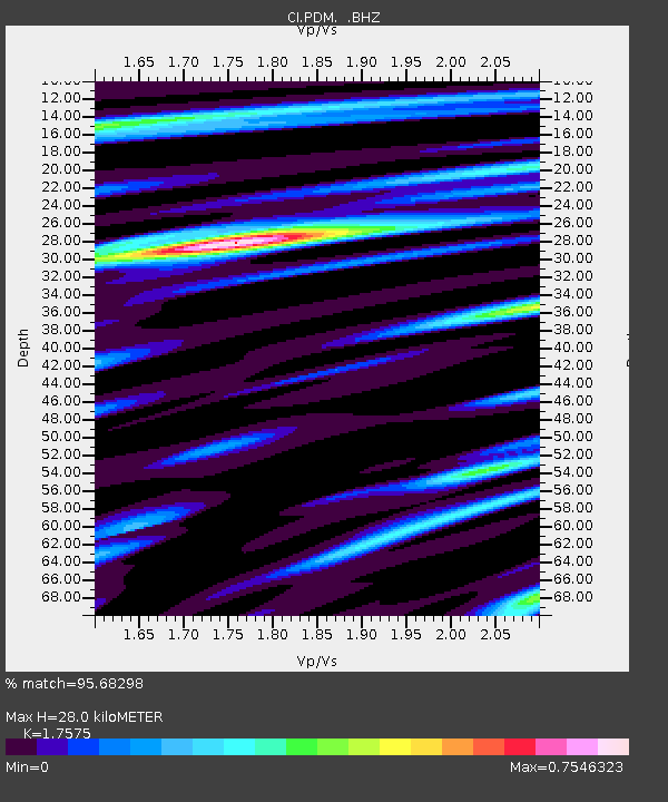
| Estimated Moho Depth: |
28.0 km |
| Estimated Crust Vp/Vs: |
1.76 |
| Assumed Crust Vp: |
6.276 km/s |
| Estimated Crust Vs: |
3.571 km/s |
| Estimated Crust Poisson's Ratio: |
0.26 |
|
| Radial Match: |
95.68298 % |
| Radial Bump: |
345 |
| Transverse Match: |
86.92048 % |
| Transverse Bump: |
400 |
| SOD ConfigId: |
2622 |
| Insert Time: |
2010-02-26 02:23:21.976 +0000 |
| GWidth: |
2.5 |
| Max Bumps: |
400 |
| Tol: |
0.001 |
|
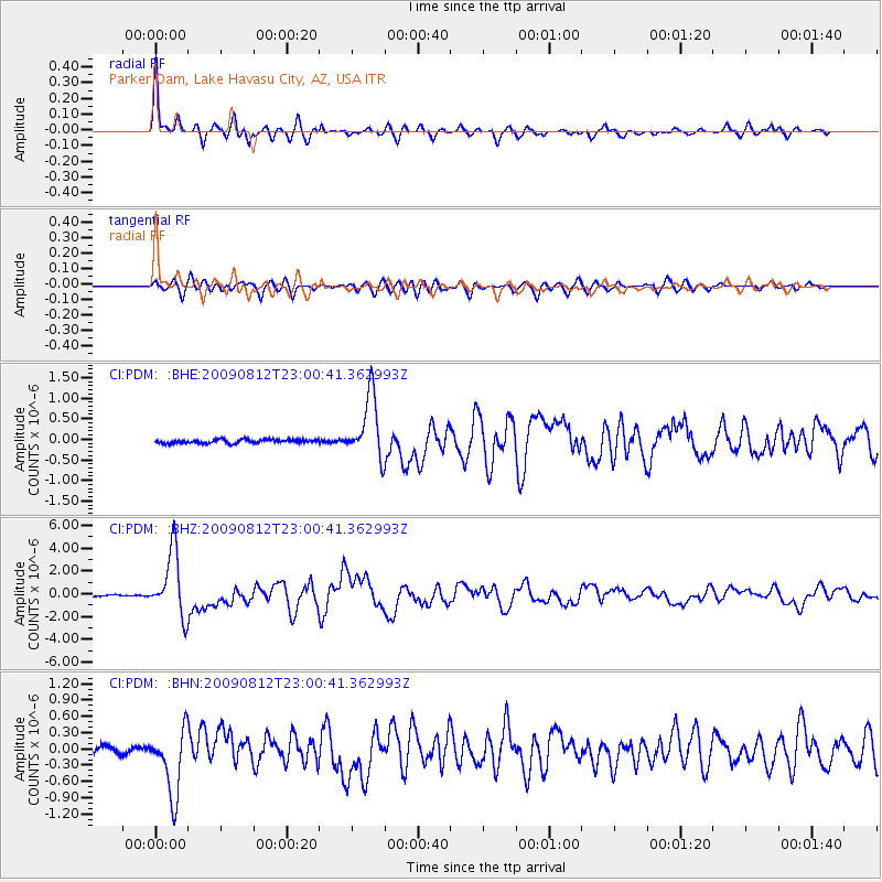
Signal To Noise
| Channel | StoN | STA | LTA |
| CI:PDM: :BHZ:20090812T23:00:41.362993Z | 48.955013 | 2.8181275E-6 | 5.756566E-8 |
| CI:PDM: :BHN:20090812T23:00:41.362993Z | 10.015334 | 6.090361E-7 | 6.081036E-8 |
| CI:PDM: :BHE:20090812T23:00:41.362993Z | 17.90668 | 7.6366604E-7 | 4.2646995E-8 |
| Arrivals |
| Ps | 3.5 SECOND |
| PpPs | 12 SECOND |
| PsPs/PpSs | 15 SECOND |


