You are here: Home > Network List > UU - University of Utah Regional Network Stations List
> Station LCMT Little Creek Mountain, UT, USA > Earthquake Result Viewer
LCMT Little Creek Mountain, UT, USA - Earthquake Result Viewer
| Earthquake location: |
Kermadec Islands Region |
| Earthquake latitude/longitude: |
-28.0/-176.4 |
| Earthquake time(UTC): |
2016/07/13 (195) 12:11:13 GMT |
| Earthquake Depth: |
12 km |
| Earthquake Magnitude: |
6.3 MWB |
| Earthquake Catalog/Contributor: |
NEIC PDE/NEIC COMCAT |
|
| Network: |
UU University of Utah Regional Network |
| Station: |
LCMT Little Creek Mountain, UT, USA |
| Lat/Lon: |
37.01 N/113.24 W |
| Elevation: |
1411 m |
|
| Distance: |
87.7 deg |
| Az: |
45.615 deg |
| Baz: |
232.115 deg |
| Ray Param: |
0.04310154 |
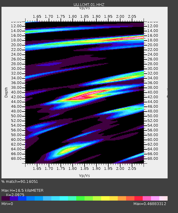
| Estimated Moho Depth: |
16.5 km |
| Estimated Crust Vp/Vs: |
2.10 |
| Assumed Crust Vp: |
6.194 km/s |
| Estimated Crust Vs: |
2.953 km/s |
| Estimated Crust Poisson's Ratio: |
0.35 |
|
| Radial Match: |
90.16051 % |
| Radial Bump: |
306 |
| Transverse Match: |
68.662636 % |
| Transverse Bump: |
310 |
| SOD ConfigId: |
1634031 |
| Insert Time: |
2016-07-27 12:13:57.528 +0000 |
| GWidth: |
2.5 |
| Max Bumps: |
400 |
| Tol: |
0.001 |
|
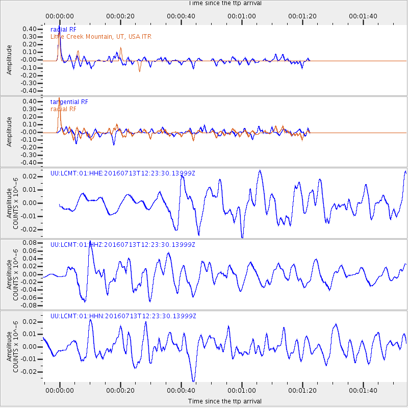
Signal To Noise
| Channel | StoN | STA | LTA |
| UU:LCMT:01:HHZ:20160713T12:23:30.13999Z | 2.7954528 | 1.18959385E-8 | 4.2554604E-9 |
| UU:LCMT:01:HHN:20160713T12:23:30.13999Z | 0.4185463 | 3.161072E-9 | 7.552503E-9 |
| UU:LCMT:01:HHE:20160713T12:23:30.13999Z | 0.9579788 | 4.5307935E-9 | 4.7295345E-9 |
| Arrivals |
| Ps | 3.0 SECOND |
| PpPs | 8.1 SECOND |
| PsPs/PpSs | 11 SECOND |


