You are here: Home > Network List > TA - USArray Transportable Network (new EarthScope stations) Stations List
> Station B18K Kokolik River, AK, USA > Earthquake Result Viewer
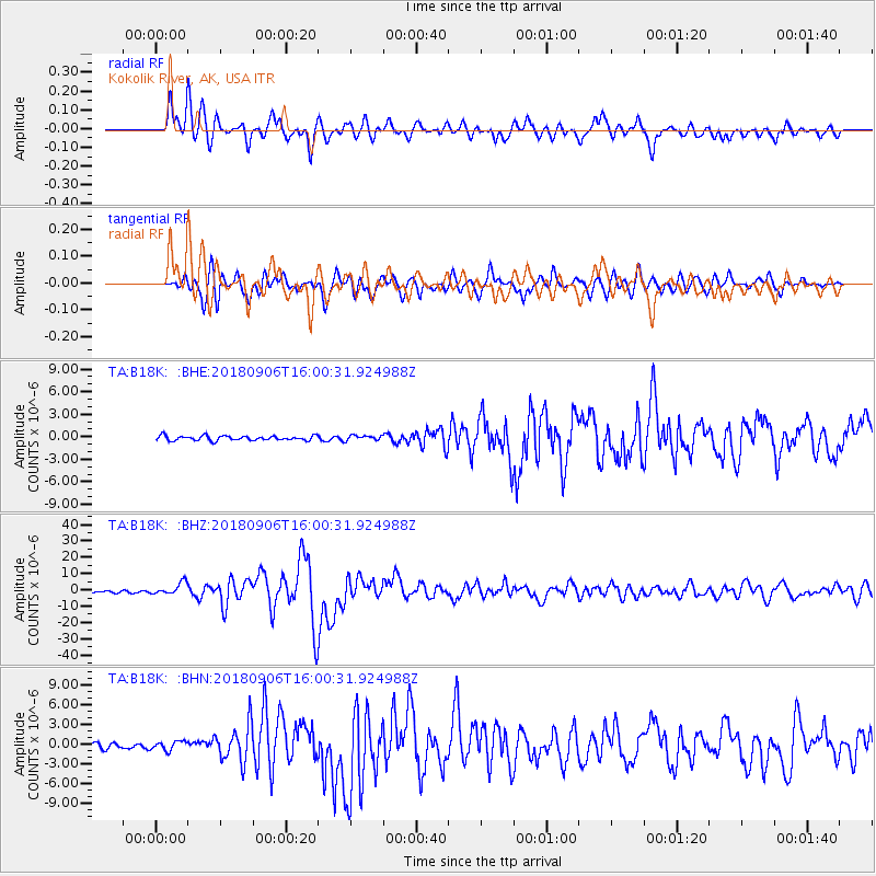
B18K Kokolik River, AK, USA - Earthquake Result Viewer
*The percent match for this event was below the threshold and hence no stack was calculated.
| Earthquake location: |
Fiji Islands |
| Earthquake latitude/longitude: |
-18.4/179.5 |
| Earthquake time(UTC): |
2018/09/06 (249) 15:49:17 GMT |
| Earthquake Depth: |
669 km |
| Earthquake Magnitude: |
8.1 Mi |
| Earthquake Catalog/Contributor: |
NEIC PDE/at |
|
| Network: |
TA USArray Transportable Network (new EarthScope stations) |
| Station: |
B18K Kokolik River, AK, USA |
| Lat/Lon: |
69.36 N/161.80 W |
| Elevation: |
222 m |
|
| Distance: |
88.5 deg |
| Az: |
6.528 deg |
| Baz: |
197.728 deg |
| Ray Param: |
$rayparam |
*The percent match for this event was below the threshold and hence was not used in the summary stack. |
|
| Radial Match: |
88.50778 % |
| Radial Bump: |
400 |
| Transverse Match: |
83.10064 % |
| Transverse Bump: |
400 |
| SOD ConfigId: |
13570011 |
| Insert Time: |
2019-05-01 03:23:55.687 +0000 |
| GWidth: |
2.5 |
| Max Bumps: |
400 |
| Tol: |
0.001 |
|
Signal To Noise
| Channel | StoN | STA | LTA |
| TA:B18K: :BHZ:20180906T16:00:31.924988Z | 6.5622234 | 3.692304E-6 | 5.626605E-7 |
| TA:B18K: :BHN:20180906T16:00:31.924988Z | 1.704405 | 6.837852E-7 | 4.0118704E-7 |
| TA:B18K: :BHE:20180906T16:00:31.924988Z | 1.1660681 | 3.4211251E-7 | 2.9338983E-7 |
| Arrivals |
| Ps | |
| PpPs | |
| PsPs/PpSs | |


